
Northside Housing and Transportation Improvements
Thank you for following this project.
The projects described on this Engage page have been completed or are continuing, and are described on other Engage Pages.
- Current and future Northside housing improvements will be shared on the Scott Street-Ravara Housing Development page.
- For recent transportation improvements on Scott Street, visit Public Works & Mobility's Transportation Projects web page.
- For engagement regarding a new park on north Scott Street follow the Northside Parks project.
Infrastructure
Scott Street Transportation Project: Phillips to Otis Sts
This project will enhance safety, mobility, and accessibility along Scott St. The City has plans ready for the first phase of this project and is seeking public input to help us prioritize the remaining project elements. Following recommendations from the North Reserve Scott Street Master Plan, and in coordination with the developer-initiated changes along the Ravara site, this project will:
- Complete missing and repair broken sidewalks on both sides of the street
- Add buffers to the bike lanes over the bridge
- Construct shared use path on the west side of the street from Turner to the north
- Install roundabouts at the intersections with Phillips and Turner
- Minimize lane widths to calm traffic and discourage cut-through truck traffic
This project will be broken into phases. The first phase will include constructing a roundabout at Phillips St., non-motorized facility enhancements from Phillips St. over the bridge to the north to Turner St., and minor striping changes. The second phase could include the continuation of the shared use path from Ravara to Otis, reconstruction of the Rodgers intersection, additional sidewalk repair/replacement, and curb extensions at side street intersections. The roundabout at Turner will likely be constructed when the street network extends west of Scott St through what is currently the City shops.
Project Status: Phase 1 will go out to bid during the fall/winter of 2024 with construction anticipated to begin during summer 2025 after school is out.
For recent transportation improvements on Scott Street, visit Public Works & Mobility's Transportation Projects web page.
Site Work and Housing Construction at the Ravara Scott Street Development
December 2024: Construction on the Scott St-Ravara housing project is advancing along Scott St. in the Northside Neighborhood. Extension of sewer, water, gas, and electric main lines to serve the development was completed this summer. Grading for new streets to and through the site was also complete this summer. Street paving is expected to occur in the spring of 2025. Construction of the first phase of Community Land Trust homes began this fall and is expected to continue through summer of 2026.
Thank you for your patience as construction activity to build new housing continues in your neighborhood!
These improvements are identified in the North Reserve Scott Street Master Plan (External link) and will support Ravara Development, LLC's planned mixed income, mixed use development. View the current timeline in the graphic or learn more about the Scott Street Development.
Are you interested in future home ownership at the Scott Street-Ravara housing project? Reach out to Hannah Kosel at the North Missoula Community Development Corporation (NMCDC) at hannah@nmcdc.org(External link). Thank you!
Turner/Worden/N 5th Mobility Project — Construction Completed
The City is constructing a Complete Streets project along Turner, Worden, and N 5th to enhance safety, mobility, and accessibility for all users along the primary route from Scott St to Orange. Project elements include:
- Sidewalks on both sides
- Bike lanes
- On-street parallel parking on south side of Turner, west side of Worden
- ADA bus stops, alleys, driveways, intersections
- Traffic calming at Neighborhood Greenway intersections
- Reconfigured Worden/N 5th intersection
October 2024: Construction is completed. Boulevard trees will be planted during spring or summer 2025.
Learn more about Right-of-Way Infrastructure Projects
Traffic Calming and Neighborhood Greenways
Through the Neighborhood Traffic Management Program (NTMP), the City is developing a comprehensive traffic calming plan for the northside neighborhood and will prioritize implementation following the Turner/Worden construction project.  The goal of this project is to reduce vehicle speeds and improve visibility along local streets while enhancing the Neighborhood Greenways – low volume, low speed local streets prioritized for people walking and biking.
The NTMP uses quick build techniques to improve safety, and the northside plan may include a combination of calming circles, stop signs, bulb outs, and/or speed humps. The Transportation Planning division will conduct outreach and engagement through the Office of Neighborhoods in fall 2024. Planned Northside Neighborhood Greenways include:
- Waverly: Turner to Defoe
- Cooley: Scott to Worden
- N 6th: Worden to Kennett
- Kennett: N 6th to N 5th
- Holmes: Charlo to Phillips
- N 1st: Worden to Ryman
- Ryman: N 1st to N 2nd
Learn more about the Neighborhood Traffic Management Program
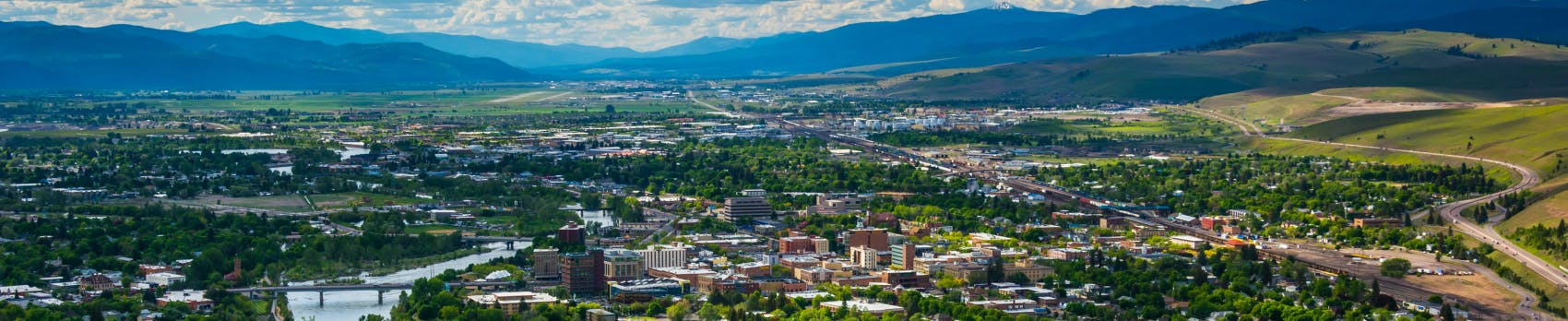
N Aerial of the Northside neighborhood and the potential location of White Pine Parkew Park on North Scott Street
December 2024 Update: The City intends to replace White Pine Park with a new larger park near the intersection of Scott Street and Rodgers Street in the Northside neighborhood. The City's Parks and Recreation Department seeks to better serve Northside residents by developing a new, five-acre park in the vicinity of White Pine Park. The City has been diligently exploring purchasing land from the Resurrection Cemetery Association (RCA) and this fall, the City Council and Missoula Redevelopment Agency Board approved funding to acquire the new park land. Purchase of this property is expected to occur in early 2025 with continued design and public engagement to follow. For more information please visit Northside Parks | Engage Missoula.
N 5th/6th Water Main Replacement Project — Completed
This project will replace approximately 2,200 feet of existing water main that has been identified as high priority replacement water main due to its material type and age. Lots of this water main was installed in 1923 or 1937. This project will reduce water system leakage and improve service. The work will take place in N 5th St W from Worden Ave to Wolf St, N 6th St W from Worden Ave to Kennett St and in Kennett St between N 5th St W and N 6th St W. In addition, there will be intersection improvements, including several bulb-outs, ADA ramps installed at intersections and damaged portions of the existing sidewalks will be replaced. Learn more about upcoming City water projects.
N 2nd Water Main Replacement Project — Completed
This project will replace approximately 2,300 feet of existing kalamein water main from 1914. Kalamein is thick-walled galvanized steel piping commonly used around the turn of the 20th century. Missoula Water is focusing its replacement projects on kalamein pipe because of its tendency to leak as it ages, particularly at the joints and seams. In addition, Missoula Water’s Facility plan has identified this section of water main as being undersized. This project will improve service and reduces water system leakage. The work will take place in N 2nd St W from Orange Street to a connection with larger water mains 2,300 feet to the east. Learn more about upcoming City water projects.
Housing
Several housing projects are planned or underway, including market rate and income qualified for sale and for rent units, consistent with the North Reserve-Scott Street Master Plan and other adopted City plans and policies. Below are details of recent housing projects, including how much Tax Increment Financing (TIF) was used for public infrastructure improvements.
Villagio Apartments — Completed
- 200 income-qualified apartments
- $1,339,178 of TIF investment for:
- Sidewalk/curb/gutter
- Public trail, water and sanitary sewer main line extensions
- Power line stabilization
- Large retaining wall that maximizes use of the property
Learn more about the Villagio Apartments
Scott Street – Ravara Development Scott St-Ravara project, May 2024
May 24, 2024 Update: Construction has begun at the site! Vertical construction of the Community Land Trust homes will begin in June 2024.
- Broke ground in September 2022
- Creation of 39 market rate apartments
- $315,100 TIF investments for:
- Remove dilapidated buildings
- Extend public infrastructure including street, curb/gutter/sidewalk, water and sewer mains and street trees
Scott Street Village - Completed
- All three phases are in final completion stage
- Creation of 142 mixed housing
- $686,896 of TIF investment for:
- Further extend water, sanitary sewer, gas and power transmission main lines
- Deconstruction of remaining industrial buildings
- Completion of streets/sidewalk/curb/gutter
Planning Documents
A Place to Call Home: Meeting Missoula’s Housing Needs
The Missoula City Council adopted a comprehensive city-wide Housing Policy, entitled "A Place to Call Home: Meeting Missoula’s Housing Needs" on June 24, 2019. Housing Policy aims to create a cohesive policy and program approach in the city to minimize barriers and provide financial incentives where possible to promote the production and preservation of diverse, healthy, and safe homes that all Missoulians can afford.
Bicycle Facilities Master Plan
The Bicycle Facilities Master Plan (BFMP) establishes a detailed strategy and project list for improving bicycling in Missoula and is the guiding document for bikeway implementation. It supports the vision and the goals of both the Long Range Transportation Plan and the Missoula Active Transportation Plan while providing greater detail for achieving a more connected bikeway network that increases access and minimizes stress for Missoula Residents.
City of Missoula's Strategic Framework
City of Missoula Strategic Plan 2024-2026: Outlines the principals and goals the City will prioritize in budgeting through fiscal year 2023.
Long Range Transportation Plan
Missoula’s Long Range Transportation Plan (LRTP) establishes regional transportation goals and provides a project list and investment strategies to support a growing and changing Missoula. Updated approximately every 4 years, the LRTP coordinates transportation projects and programs carried out by various partners across the region to ensure our system is comprehensive and coordinated as needs and priorities shift over time.
Pedestrian Facilities Master Plan
The Pedestrian Facilities Master Plan (PFMP) presents a strategy for providing a connected, safe, and accessible pedestrian network for users of all ages and abilities within the Missoula urban area. The plan includes a detailed assessment of Missoula’s existing pedestrian network and anticipated needs, as well as evaluation of project prioritization processes and funding recommendations. In addition to planning for future infrastructure improvements, the PFMP serves as an asset management plan for pedestrian facilities such as sidewalks, curb ramps, and crossing safety improvements.
North Reserve-Scott Street Urban Renewal District (URD) :
- Adopted in 2014 to help support redevelopment of the area, in alignment with the goals of the NRSS URD Plan (and later) the master plan.
- Phased implementation, until the district closes (likely in 2045)
- Projects planned or underway:
- Street extensions to Charlo, Shakespeare, Palmer; improvements on Scott Street
- Likely investments in park expansion in the neighborhood
- Public/private partnerships that add or retain jobs and/or housing of all types
- Likely investments to improve Grant Creek Road, other key transportation corridor
North Reserve-Scott Street Master Plan
Conceptual, road map to guide development, prioritize URD investments in transportation infrastructure, housing, businesses, and other land uses Guides public and private investment in the urban renewal district
 North Reserve-Scott Street Master Plan Concept Map, Updated August 2021
Ask a question
Questions and answers will be posted publicly with your screen name.
Signup Banner

Who's Listening
-

Phone 406-552-6155 Email gorskia@ci.missoula.mt.us -

Email adamsj@ci.missoula.mt.us -

Phone 406-552-6668 Email WilsonA@ci.missoula.mt.us -
AG
Phone 406-552-6648 Email GeigerA@ci.missoula.mt.us
Documents
-
 White Pine Park Presentation.pdf (1.19 MB) (pdf)
-
Northside Public Meeting Re-cap Email.pdf (142 KB) (pdf)
-
Scott St. Walking Audit Notes - March 2, 2023 (125 KB) (pdf)
-
2023-05-22 Northside Pedestrian Bridge FAQ.pdf (178 KB) (pdf)
-
MRA Press Release - Scott Street-Ravara Development MRA Approval 12.4.23.pdf (403 KB) (pdf)
-
Northside community housing and transportation meeting 1.23.pdf (9.6 MB) (pdf)

Thank you for your contribution!
Help us reach out to more people in the community
Share this with family and friends