
Greenough Heights Subdivision and Rezoning
On April 11, 2022, Missoula City Council voted to adopt an ordinance to rezone the subject property and to grant preliminary plat approval of the Greenough Heights Subdivision. Consultation has concluded.
UPDATE: On April 11, 2022, Missoula City Council voted to adopt an ordinance to rezone the subject property and to grant preliminary plat approval of the Greenough Heights Subdivision. This case is now closed for comment.
PROJECT DESCRIPTION:
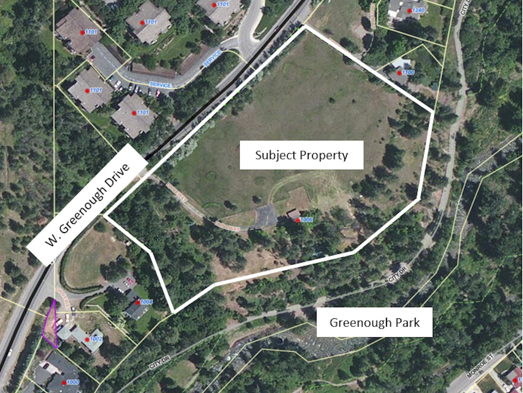
An application is under review for subdivision and rezoning of 5.79 acres of property located at 1006 W. Greenough Drive and legally described as Areas 15 and 16 shown on Deed Exhibit No. 3161, Records of Missoula County, located in the NE ¼ of the NE ¼ of Section 22, Township 13 North, Range 19 West, P.M.M.
If approved, the property willContinue reading
UPDATE: On April 11, 2022, Missoula City Council voted to adopt an ordinance to rezone the subject property and to grant preliminary plat approval of the Greenough Heights Subdivision. This case is now closed for comment.
PROJECT DESCRIPTION:
An application is under review for subdivision and rezoning of 5.79 acres of property located at 1006 W. Greenough Drive and legally described as Areas 15 and 16 shown on Deed Exhibit No. 3161, Records of Missoula County, located in the NE ¼ of the NE ¼ of Section 22, Township 13 North, Range 19 West, P.M.M.
If approved, the property will be subdivided into 20 residential lots zoned R8 Residential and one open space parcel zoned OP1 Open Space. Currently, the majority of the property is zoned R8 Residential with a strip of land along Greenough Park zoned OP1 Open Space. The zone change would result in a reconfiguration of the R8 and OP1 zoned areas on the property such that the entirety of the residential lots would be zoned R8 and the open space parcel zoned OP1. No additional or more intensive zoning districts are proposed.
The R8 Residential zoning district allows an average lot size of 8,000 square feet and the OP1 Open Space zoning district allows for parks and recreational land uses. The applicant seeks to develop 20 detached houses connected to city services and a new public road and alley to access the residential lots. The open space parcel is adjacent to Greenough Park.
City Council may either approve, approve with conditions, or deny the subdivision request and either approve or deny the rezoning request.
The subject property is located in the Lower Rattlesnake Neighborhood Council area and City Council Ward 1.
PROJECT APPLICATION LINKS:
The application, preliminary plat, and other materials can be viewed here: https://www.ci.missoula.mt.us/2864/Greenough-Heights-Subdivision-and-Rezone
PROJECT TIMELINE:
City Council: March 14th, 2022 at 6:00pm – First reading of the rezoning ordinance and referral to the Land Use and Planning Committee
Planning Board: March 22nd, 2022 at 6:00pm – Public hearing
Land Use and Planning Committee: March 30th, 2022 (Time TBD) Pre-public hearing informational only meeting
City Council: April 4th, 2022 at 6:00pm – Public hearing
Land Use and Planning Committee: April 6th, 2022 (tentative meeting date/time TBD) – Post-public hearing informational only meeting
City Council: April 11th, 2022 at 6:00 pm – Final Consideration
All meetings will be virtually via Zoom, with more information to be posted here: https://www.ci.missoula.mt.us/1149/AgendasWebcastsMinutes(External link)
PROJECT COMMENT DEADLINE:
Public comment will be taken by City Council until the public hearings are closed. Comments can be submitted through Engage Missoula, via email to the planner noted below, by mailing in a letter to the City of Missoula office at 435 Ryman Street, Missoula, MT 59802, or during the public meetings. Provide your comment by Thursday, March 10, 2022 to be included in the staff report provided to Planning Board and City Council. Your comments may be considered by City Council in their decision to approve or deny this request.
PROJECT PLANNER:
The project planner is Dave DeGrandpre, who can be reached at (406) 529-0709 or degrandpred@ci.missoula.mt.us.
On April 11, 2022, Missoula City Council voted to adopt an ordinance to rezone the subject property and to grant preliminary plat approval of the Greenough Heights Subdivision. Consultation has concluded.
Submit public comment or ask a question below. Comments will be sent to City Council and Planning Board for review. Questions will be sent to the case planner and a response will be posted below. Some questions may require additional staff research which can take a few days. Thank you for staying engaged!
-
Share Many of the homes sites are shown on very steep slopes above Rattlesnake Creek. Their slope table in the Slope Analysis attachment says maximum slope of 112% which is crazy steep and actually doesn't make sense. Their application says the project won't have an adverse impact on wildlife and natural resources, but removing trees, building on steep slopes (or putting fill there to invent flat land), and putting impervious surfaces close to the edge of their property is a recipe for erosion and lots of polluted runoff into Rattlesnake Creek. The buildable areas they're showing are huge and NOT the size of home we need in Missoula right now. How about smaller, denser units so that leaves space for the entire steep area along Rattlesnake Creek to remain as buffer? on Facebook Share Many of the homes sites are shown on very steep slopes above Rattlesnake Creek. Their slope table in the Slope Analysis attachment says maximum slope of 112% which is crazy steep and actually doesn't make sense. Their application says the project won't have an adverse impact on wildlife and natural resources, but removing trees, building on steep slopes (or putting fill there to invent flat land), and putting impervious surfaces close to the edge of their property is a recipe for erosion and lots of polluted runoff into Rattlesnake Creek. The buildable areas they're showing are huge and NOT the size of home we need in Missoula right now. How about smaller, denser units so that leaves space for the entire steep area along Rattlesnake Creek to remain as buffer? on Twitter Share Many of the homes sites are shown on very steep slopes above Rattlesnake Creek. Their slope table in the Slope Analysis attachment says maximum slope of 112% which is crazy steep and actually doesn't make sense. Their application says the project won't have an adverse impact on wildlife and natural resources, but removing trees, building on steep slopes (or putting fill there to invent flat land), and putting impervious surfaces close to the edge of their property is a recipe for erosion and lots of polluted runoff into Rattlesnake Creek. The buildable areas they're showing are huge and NOT the size of home we need in Missoula right now. How about smaller, denser units so that leaves space for the entire steep area along Rattlesnake Creek to remain as buffer? on Linkedin Email Many of the homes sites are shown on very steep slopes above Rattlesnake Creek. Their slope table in the Slope Analysis attachment says maximum slope of 112% which is crazy steep and actually doesn't make sense. Their application says the project won't have an adverse impact on wildlife and natural resources, but removing trees, building on steep slopes (or putting fill there to invent flat land), and putting impervious surfaces close to the edge of their property is a recipe for erosion and lots of polluted runoff into Rattlesnake Creek. The buildable areas they're showing are huge and NOT the size of home we need in Missoula right now. How about smaller, denser units so that leaves space for the entire steep area along Rattlesnake Creek to remain as buffer? link
Many of the homes sites are shown on very steep slopes above Rattlesnake Creek. Their slope table in the Slope Analysis attachment says maximum slope of 112% which is crazy steep and actually doesn't make sense. Their application says the project won't have an adverse impact on wildlife and natural resources, but removing trees, building on steep slopes (or putting fill there to invent flat land), and putting impervious surfaces close to the edge of their property is a recipe for erosion and lots of polluted runoff into Rattlesnake Creek. The buildable areas they're showing are huge and NOT the size of home we need in Missoula right now. How about smaller, denser units so that leaves space for the entire steep area along Rattlesnake Creek to remain as buffer?
Wilma asked about 4 years agoThank you for submitting public comment. Your comment has been added to the record.
-
Share I am skeptical about this proposed development for several reasons, not the least of which is the increased traffic congestion on an already congested street, only made worse when a train backs up traffic. As has already been pointed out, the Rattlesnake has but two routes of vehicle access, which has all kinds of implications for traffic flow, safety, and general neighborhood health. The proposed development can't address these issues, but they should be considered by the city in their assessment of the viability of this proposed development. The Rattlesnake has traffic, safety, and environmental issues that are only made worse by every new development that occurs in the drainage. I only wish that quality of life for residents carried some higher value with the city and the developers than making more money in an already bloated housing market. on Facebook Share I am skeptical about this proposed development for several reasons, not the least of which is the increased traffic congestion on an already congested street, only made worse when a train backs up traffic. As has already been pointed out, the Rattlesnake has but two routes of vehicle access, which has all kinds of implications for traffic flow, safety, and general neighborhood health. The proposed development can't address these issues, but they should be considered by the city in their assessment of the viability of this proposed development. The Rattlesnake has traffic, safety, and environmental issues that are only made worse by every new development that occurs in the drainage. I only wish that quality of life for residents carried some higher value with the city and the developers than making more money in an already bloated housing market. on Twitter Share I am skeptical about this proposed development for several reasons, not the least of which is the increased traffic congestion on an already congested street, only made worse when a train backs up traffic. As has already been pointed out, the Rattlesnake has but two routes of vehicle access, which has all kinds of implications for traffic flow, safety, and general neighborhood health. The proposed development can't address these issues, but they should be considered by the city in their assessment of the viability of this proposed development. The Rattlesnake has traffic, safety, and environmental issues that are only made worse by every new development that occurs in the drainage. I only wish that quality of life for residents carried some higher value with the city and the developers than making more money in an already bloated housing market. on Linkedin Email I am skeptical about this proposed development for several reasons, not the least of which is the increased traffic congestion on an already congested street, only made worse when a train backs up traffic. As has already been pointed out, the Rattlesnake has but two routes of vehicle access, which has all kinds of implications for traffic flow, safety, and general neighborhood health. The proposed development can't address these issues, but they should be considered by the city in their assessment of the viability of this proposed development. The Rattlesnake has traffic, safety, and environmental issues that are only made worse by every new development that occurs in the drainage. I only wish that quality of life for residents carried some higher value with the city and the developers than making more money in an already bloated housing market. link
I am skeptical about this proposed development for several reasons, not the least of which is the increased traffic congestion on an already congested street, only made worse when a train backs up traffic. As has already been pointed out, the Rattlesnake has but two routes of vehicle access, which has all kinds of implications for traffic flow, safety, and general neighborhood health. The proposed development can't address these issues, but they should be considered by the city in their assessment of the viability of this proposed development. The Rattlesnake has traffic, safety, and environmental issues that are only made worse by every new development that occurs in the drainage. I only wish that quality of life for residents carried some higher value with the city and the developers than making more money in an already bloated housing market.
PaulH asked about 4 years agoThank you for submitting public comment. Your comment has been added to the record.
-
Share I thought Missoula was the Garden City? Not the city of apartments, townhouses, and housing projects? The Garden City seems to be shrinking. The proposed development in the Rattlesnake is a farce, and should be rejected. There are too many negatives against this project, see the responses below. The way our local govt plans lately, why not just put more banks, storage units, phone stores, and casinos in. They really know positive growth. dON'T THEY! on Facebook Share I thought Missoula was the Garden City? Not the city of apartments, townhouses, and housing projects? The Garden City seems to be shrinking. The proposed development in the Rattlesnake is a farce, and should be rejected. There are too many negatives against this project, see the responses below. The way our local govt plans lately, why not just put more banks, storage units, phone stores, and casinos in. They really know positive growth. dON'T THEY! on Twitter Share I thought Missoula was the Garden City? Not the city of apartments, townhouses, and housing projects? The Garden City seems to be shrinking. The proposed development in the Rattlesnake is a farce, and should be rejected. There are too many negatives against this project, see the responses below. The way our local govt plans lately, why not just put more banks, storage units, phone stores, and casinos in. They really know positive growth. dON'T THEY! on Linkedin Email I thought Missoula was the Garden City? Not the city of apartments, townhouses, and housing projects? The Garden City seems to be shrinking. The proposed development in the Rattlesnake is a farce, and should be rejected. There are too many negatives against this project, see the responses below. The way our local govt plans lately, why not just put more banks, storage units, phone stores, and casinos in. They really know positive growth. dON'T THEY! link
I thought Missoula was the Garden City? Not the city of apartments, townhouses, and housing projects? The Garden City seems to be shrinking. The proposed development in the Rattlesnake is a farce, and should be rejected. There are too many negatives against this project, see the responses below. The way our local govt plans lately, why not just put more banks, storage units, phone stores, and casinos in. They really know positive growth. dON'T THEY!
dicoman asked about 4 years agoThank you for submitting public comment. Your comment will be sent to City Council for review.
-
Share I agree that it would be good for Missoula to have more housing for lower- and middle-income families. Will this project address this issue? I live one block off of Van Buren Street in the Lower Rattlesnake. For many years I have seen the amount of traffic steadily increase on Van Buren as more housing has been developed in the Rattlesnake Valley because there are only two streets that access the city and the University District. More building means more traffic and more noise and congestion for people in the Lower Rattlesnake, especially those who live on Greenough and Van Buren. I think that this inadequate infrastructure issue has been ignored. I am also concerned about the impacts on Greenough Park and Rattlesnake Creek. Will erosion increase and end up in the creek? Will there be new, unauthorized trails down into the Park? The City Planning Dept. denied me a variance on a 80 sq ft addition to my house because I couldn’t show hardship. The developer of the Greenough property is seeking two variances; have they shown hardship? on Facebook Share I agree that it would be good for Missoula to have more housing for lower- and middle-income families. Will this project address this issue? I live one block off of Van Buren Street in the Lower Rattlesnake. For many years I have seen the amount of traffic steadily increase on Van Buren as more housing has been developed in the Rattlesnake Valley because there are only two streets that access the city and the University District. More building means more traffic and more noise and congestion for people in the Lower Rattlesnake, especially those who live on Greenough and Van Buren. I think that this inadequate infrastructure issue has been ignored. I am also concerned about the impacts on Greenough Park and Rattlesnake Creek. Will erosion increase and end up in the creek? Will there be new, unauthorized trails down into the Park? The City Planning Dept. denied me a variance on a 80 sq ft addition to my house because I couldn’t show hardship. The developer of the Greenough property is seeking two variances; have they shown hardship? on Twitter Share I agree that it would be good for Missoula to have more housing for lower- and middle-income families. Will this project address this issue? I live one block off of Van Buren Street in the Lower Rattlesnake. For many years I have seen the amount of traffic steadily increase on Van Buren as more housing has been developed in the Rattlesnake Valley because there are only two streets that access the city and the University District. More building means more traffic and more noise and congestion for people in the Lower Rattlesnake, especially those who live on Greenough and Van Buren. I think that this inadequate infrastructure issue has been ignored. I am also concerned about the impacts on Greenough Park and Rattlesnake Creek. Will erosion increase and end up in the creek? Will there be new, unauthorized trails down into the Park? The City Planning Dept. denied me a variance on a 80 sq ft addition to my house because I couldn’t show hardship. The developer of the Greenough property is seeking two variances; have they shown hardship? on Linkedin Email I agree that it would be good for Missoula to have more housing for lower- and middle-income families. Will this project address this issue? I live one block off of Van Buren Street in the Lower Rattlesnake. For many years I have seen the amount of traffic steadily increase on Van Buren as more housing has been developed in the Rattlesnake Valley because there are only two streets that access the city and the University District. More building means more traffic and more noise and congestion for people in the Lower Rattlesnake, especially those who live on Greenough and Van Buren. I think that this inadequate infrastructure issue has been ignored. I am also concerned about the impacts on Greenough Park and Rattlesnake Creek. Will erosion increase and end up in the creek? Will there be new, unauthorized trails down into the Park? The City Planning Dept. denied me a variance on a 80 sq ft addition to my house because I couldn’t show hardship. The developer of the Greenough property is seeking two variances; have they shown hardship? link
I agree that it would be good for Missoula to have more housing for lower- and middle-income families. Will this project address this issue? I live one block off of Van Buren Street in the Lower Rattlesnake. For many years I have seen the amount of traffic steadily increase on Van Buren as more housing has been developed in the Rattlesnake Valley because there are only two streets that access the city and the University District. More building means more traffic and more noise and congestion for people in the Lower Rattlesnake, especially those who live on Greenough and Van Buren. I think that this inadequate infrastructure issue has been ignored. I am also concerned about the impacts on Greenough Park and Rattlesnake Creek. Will erosion increase and end up in the creek? Will there be new, unauthorized trails down into the Park? The City Planning Dept. denied me a variance on a 80 sq ft addition to my house because I couldn’t show hardship. The developer of the Greenough property is seeking two variances; have they shown hardship?
Peter70 asked about 4 years agoThank you for submitting public comment. Your comment will be sent to City Council for review.
-
Share Traffic on Greenough Drive has increased over the past years and the street now gets congested, especially during commute hours. The Greenough Heights development will add a four-way intersection at Peggio Lane, bringing in additional vehicles. This is a recipe for more vehicle-vehicle and vehicle-deer collisions. To alleviate the traffic hazards the Greenough Heights development will bring to the neighborhood, a traffic circle needs to be built at this intersection. Rather than allowing the variances the developer seeks, the project needs to be modified. First, a traffic circle, instead of a four-way intersection, is needed at Peggio Lane. This will allow left-turning vehicles from the development to smoothly enter Greenough Drive and not be a hazard to drivers. To accomplish this, lots 1 and 2 of the development should be designated for the traffic circle. Second, the southern entrance to the development should be restricted to right turns only. These changes will pay off in the years to come by reducing traffic accidents, improving traffic flow, and preserving wildlife. on Facebook Share Traffic on Greenough Drive has increased over the past years and the street now gets congested, especially during commute hours. The Greenough Heights development will add a four-way intersection at Peggio Lane, bringing in additional vehicles. This is a recipe for more vehicle-vehicle and vehicle-deer collisions. To alleviate the traffic hazards the Greenough Heights development will bring to the neighborhood, a traffic circle needs to be built at this intersection. Rather than allowing the variances the developer seeks, the project needs to be modified. First, a traffic circle, instead of a four-way intersection, is needed at Peggio Lane. This will allow left-turning vehicles from the development to smoothly enter Greenough Drive and not be a hazard to drivers. To accomplish this, lots 1 and 2 of the development should be designated for the traffic circle. Second, the southern entrance to the development should be restricted to right turns only. These changes will pay off in the years to come by reducing traffic accidents, improving traffic flow, and preserving wildlife. on Twitter Share Traffic on Greenough Drive has increased over the past years and the street now gets congested, especially during commute hours. The Greenough Heights development will add a four-way intersection at Peggio Lane, bringing in additional vehicles. This is a recipe for more vehicle-vehicle and vehicle-deer collisions. To alleviate the traffic hazards the Greenough Heights development will bring to the neighborhood, a traffic circle needs to be built at this intersection. Rather than allowing the variances the developer seeks, the project needs to be modified. First, a traffic circle, instead of a four-way intersection, is needed at Peggio Lane. This will allow left-turning vehicles from the development to smoothly enter Greenough Drive and not be a hazard to drivers. To accomplish this, lots 1 and 2 of the development should be designated for the traffic circle. Second, the southern entrance to the development should be restricted to right turns only. These changes will pay off in the years to come by reducing traffic accidents, improving traffic flow, and preserving wildlife. on Linkedin Email Traffic on Greenough Drive has increased over the past years and the street now gets congested, especially during commute hours. The Greenough Heights development will add a four-way intersection at Peggio Lane, bringing in additional vehicles. This is a recipe for more vehicle-vehicle and vehicle-deer collisions. To alleviate the traffic hazards the Greenough Heights development will bring to the neighborhood, a traffic circle needs to be built at this intersection. Rather than allowing the variances the developer seeks, the project needs to be modified. First, a traffic circle, instead of a four-way intersection, is needed at Peggio Lane. This will allow left-turning vehicles from the development to smoothly enter Greenough Drive and not be a hazard to drivers. To accomplish this, lots 1 and 2 of the development should be designated for the traffic circle. Second, the southern entrance to the development should be restricted to right turns only. These changes will pay off in the years to come by reducing traffic accidents, improving traffic flow, and preserving wildlife. link
Traffic on Greenough Drive has increased over the past years and the street now gets congested, especially during commute hours. The Greenough Heights development will add a four-way intersection at Peggio Lane, bringing in additional vehicles. This is a recipe for more vehicle-vehicle and vehicle-deer collisions. To alleviate the traffic hazards the Greenough Heights development will bring to the neighborhood, a traffic circle needs to be built at this intersection. Rather than allowing the variances the developer seeks, the project needs to be modified. First, a traffic circle, instead of a four-way intersection, is needed at Peggio Lane. This will allow left-turning vehicles from the development to smoothly enter Greenough Drive and not be a hazard to drivers. To accomplish this, lots 1 and 2 of the development should be designated for the traffic circle. Second, the southern entrance to the development should be restricted to right turns only. These changes will pay off in the years to come by reducing traffic accidents, improving traffic flow, and preserving wildlife.
BobB asked about 4 years agoThank you for submitting public comment. Your comment will be sent to City Council for review.
-
Share I live in the area and have several comments on tis proposal. Beth Berlin 1. The developers have stated that this development is NOT in the air stagnation zone. It is. As Such, there are specific requirements that the developer must follow during construction and possibly post construction. Please have air quality staff and the Missoula City County Health department comment on this project and others. 2. The developers have stated that this subdivision will have no considerable transportation impacts or impacts to community services on the surrounding area. The only transportation evaluation pertained to the impacts from the estimated vehicle miles traveled by the residents in the proposed subdivision. Specifically, the project may have considerable impacts to those using the Duncan drive corridor for both residential and recreational purposes. Residents in the area will tell you that access on to Duncan drive is already challenging due to train traffic at the bottom of Duncan drive causing backups due to current residential traffic and from others accessing recreational areas up Duncan Drive and in other areas of the Rattlesnake. Without taking the necessary steps to mitigate the impacts of more vehicles, turning left on to Duncan drive from this proposed development will be risky and dangerous. Limited one road access, increasing train traffic, access to the Waterworks hill recreation area already makes travel on Duncan very challenging, and this is not even mentioned in the proposal. Further, the proposal includes no discussion or evaluation of the cumulative transportation impacts on emergency response plans or policies. While this may not be currently required in proposals, the community must consider how continued development up Duncan drive, the Rattlesnake corridor, and in other fire prone areas directly impacts the ability of both residents and recreationists to exit the area safely in the case of a wildland fire. What community emergency response plans for wildfire or other emergencies have been developed? Do they adequately consider the number of residents or visitors? Any housing proposal in these areas must consider these risks. Saying police services are near the area does not adequately or comprehensively address this need. We need further community discussions about how to best mitigate these risks and be prepared to adjust our community development strategies accordingly. 3. While the density in the proposal does meet the thresholds in the Comprehensive plan and updates and in recommended zoning, this proposal does mention the constraints to development on the site due to some severe (possibly unstable) slopes where buildings are proposed. The staff report recommends further geotechnical evaluations to determine to stability of the soils on sloped area, and I support this requirement as a condition of development. Unstable slopes may mean even less development on the site than what is currently proposed. 4. While the impacts on wildlife on this important recreation corridor are barely mentioned in the proposal, like the issue of fire impacts, this too begs for a much larger community discussion. There are cumulative impacts of development on wildlife corridors that must be considered. Much of our wildlife uses the creek as a means to travel to and from the Rattlesnake recreation and wilderness areas. The creek is also an important fishery that is currently being restored upstream. We know from wildlife managers that with climate change and more droughts, many species will be pushed down from higher elevations into lower areas - including into our wildland urban interface - in search of food. The more people, the more chances for conflicts with humans. How do we adjust our developments to avoid more conflicts and impacts? 5. As far as I can tell, these was one poorly attended neighborhood meeting during Covid last year to seek neighborhood input on this subdivision proposal. Meeting notices went to the neighbors but to no one else in the area. The impacts of this subdivision and others on the entire rattlesnake area needs to be considered. As stated above, the more development, the more vehicles, and the cumulative impacts of this must be considered. Residents in the area need to be given ample opportunities to comment on these proposals in the planning stages, and in this day and age of social media and electronic correspondence there is no excuse not to provide such opportunities. Public participation 101 tells us that the value in public participation is that we end up with better solutions. That is because the people living in the area know it the best. For future projects, I encourage the City to provide further opportunities for meaningful public and neighborhood participation and dialogue beyond just what is required by the subdivision review process. 6. Finally, we must be clear that the Rattlesnake has always been a very desirable area both as a residential area and a recreation area for our entire community. Prices have been high compared to other areas for decades. Therefore, it is important to note that given the current cost of housing in the area, these homes will likely be some of the highest priced homes in our community, likely to each sell for over a million dollars. The desire of some on the council to seek maximum density in this proposal because they believe it will result in more affordable housing is misguided. It will only result in more million dollar homes on site, driving up the average cost per home even further. After years working on affording housing development in our community, I can say that the only affordable housing is that which is developed by a real affordable housing nonprofit such as HomeWord, the north Missoula Community Development Corporation, the Missoula Housing Authority, and their partners. Density can only ensure real affordability if it is specifically baked into the project as a requirement, and as you know, state law recently made that an impossible ask of for profit developers. on Facebook Share I live in the area and have several comments on tis proposal. Beth Berlin 1. The developers have stated that this development is NOT in the air stagnation zone. It is. As Such, there are specific requirements that the developer must follow during construction and possibly post construction. Please have air quality staff and the Missoula City County Health department comment on this project and others. 2. The developers have stated that this subdivision will have no considerable transportation impacts or impacts to community services on the surrounding area. The only transportation evaluation pertained to the impacts from the estimated vehicle miles traveled by the residents in the proposed subdivision. Specifically, the project may have considerable impacts to those using the Duncan drive corridor for both residential and recreational purposes. Residents in the area will tell you that access on to Duncan drive is already challenging due to train traffic at the bottom of Duncan drive causing backups due to current residential traffic and from others accessing recreational areas up Duncan Drive and in other areas of the Rattlesnake. Without taking the necessary steps to mitigate the impacts of more vehicles, turning left on to Duncan drive from this proposed development will be risky and dangerous. Limited one road access, increasing train traffic, access to the Waterworks hill recreation area already makes travel on Duncan very challenging, and this is not even mentioned in the proposal. Further, the proposal includes no discussion or evaluation of the cumulative transportation impacts on emergency response plans or policies. While this may not be currently required in proposals, the community must consider how continued development up Duncan drive, the Rattlesnake corridor, and in other fire prone areas directly impacts the ability of both residents and recreationists to exit the area safely in the case of a wildland fire. What community emergency response plans for wildfire or other emergencies have been developed? Do they adequately consider the number of residents or visitors? Any housing proposal in these areas must consider these risks. Saying police services are near the area does not adequately or comprehensively address this need. We need further community discussions about how to best mitigate these risks and be prepared to adjust our community development strategies accordingly. 3. While the density in the proposal does meet the thresholds in the Comprehensive plan and updates and in recommended zoning, this proposal does mention the constraints to development on the site due to some severe (possibly unstable) slopes where buildings are proposed. The staff report recommends further geotechnical evaluations to determine to stability of the soils on sloped area, and I support this requirement as a condition of development. Unstable slopes may mean even less development on the site than what is currently proposed. 4. While the impacts on wildlife on this important recreation corridor are barely mentioned in the proposal, like the issue of fire impacts, this too begs for a much larger community discussion. There are cumulative impacts of development on wildlife corridors that must be considered. Much of our wildlife uses the creek as a means to travel to and from the Rattlesnake recreation and wilderness areas. The creek is also an important fishery that is currently being restored upstream. We know from wildlife managers that with climate change and more droughts, many species will be pushed down from higher elevations into lower areas - including into our wildland urban interface - in search of food. The more people, the more chances for conflicts with humans. How do we adjust our developments to avoid more conflicts and impacts? 5. As far as I can tell, these was one poorly attended neighborhood meeting during Covid last year to seek neighborhood input on this subdivision proposal. Meeting notices went to the neighbors but to no one else in the area. The impacts of this subdivision and others on the entire rattlesnake area needs to be considered. As stated above, the more development, the more vehicles, and the cumulative impacts of this must be considered. Residents in the area need to be given ample opportunities to comment on these proposals in the planning stages, and in this day and age of social media and electronic correspondence there is no excuse not to provide such opportunities. Public participation 101 tells us that the value in public participation is that we end up with better solutions. That is because the people living in the area know it the best. For future projects, I encourage the City to provide further opportunities for meaningful public and neighborhood participation and dialogue beyond just what is required by the subdivision review process. 6. Finally, we must be clear that the Rattlesnake has always been a very desirable area both as a residential area and a recreation area for our entire community. Prices have been high compared to other areas for decades. Therefore, it is important to note that given the current cost of housing in the area, these homes will likely be some of the highest priced homes in our community, likely to each sell for over a million dollars. The desire of some on the council to seek maximum density in this proposal because they believe it will result in more affordable housing is misguided. It will only result in more million dollar homes on site, driving up the average cost per home even further. After years working on affording housing development in our community, I can say that the only affordable housing is that which is developed by a real affordable housing nonprofit such as HomeWord, the north Missoula Community Development Corporation, the Missoula Housing Authority, and their partners. Density can only ensure real affordability if it is specifically baked into the project as a requirement, and as you know, state law recently made that an impossible ask of for profit developers. on Twitter Share I live in the area and have several comments on tis proposal. Beth Berlin 1. The developers have stated that this development is NOT in the air stagnation zone. It is. As Such, there are specific requirements that the developer must follow during construction and possibly post construction. Please have air quality staff and the Missoula City County Health department comment on this project and others. 2. The developers have stated that this subdivision will have no considerable transportation impacts or impacts to community services on the surrounding area. The only transportation evaluation pertained to the impacts from the estimated vehicle miles traveled by the residents in the proposed subdivision. Specifically, the project may have considerable impacts to those using the Duncan drive corridor for both residential and recreational purposes. Residents in the area will tell you that access on to Duncan drive is already challenging due to train traffic at the bottom of Duncan drive causing backups due to current residential traffic and from others accessing recreational areas up Duncan Drive and in other areas of the Rattlesnake. Without taking the necessary steps to mitigate the impacts of more vehicles, turning left on to Duncan drive from this proposed development will be risky and dangerous. Limited one road access, increasing train traffic, access to the Waterworks hill recreation area already makes travel on Duncan very challenging, and this is not even mentioned in the proposal. Further, the proposal includes no discussion or evaluation of the cumulative transportation impacts on emergency response plans or policies. While this may not be currently required in proposals, the community must consider how continued development up Duncan drive, the Rattlesnake corridor, and in other fire prone areas directly impacts the ability of both residents and recreationists to exit the area safely in the case of a wildland fire. What community emergency response plans for wildfire or other emergencies have been developed? Do they adequately consider the number of residents or visitors? Any housing proposal in these areas must consider these risks. Saying police services are near the area does not adequately or comprehensively address this need. We need further community discussions about how to best mitigate these risks and be prepared to adjust our community development strategies accordingly. 3. While the density in the proposal does meet the thresholds in the Comprehensive plan and updates and in recommended zoning, this proposal does mention the constraints to development on the site due to some severe (possibly unstable) slopes where buildings are proposed. The staff report recommends further geotechnical evaluations to determine to stability of the soils on sloped area, and I support this requirement as a condition of development. Unstable slopes may mean even less development on the site than what is currently proposed. 4. While the impacts on wildlife on this important recreation corridor are barely mentioned in the proposal, like the issue of fire impacts, this too begs for a much larger community discussion. There are cumulative impacts of development on wildlife corridors that must be considered. Much of our wildlife uses the creek as a means to travel to and from the Rattlesnake recreation and wilderness areas. The creek is also an important fishery that is currently being restored upstream. We know from wildlife managers that with climate change and more droughts, many species will be pushed down from higher elevations into lower areas - including into our wildland urban interface - in search of food. The more people, the more chances for conflicts with humans. How do we adjust our developments to avoid more conflicts and impacts? 5. As far as I can tell, these was one poorly attended neighborhood meeting during Covid last year to seek neighborhood input on this subdivision proposal. Meeting notices went to the neighbors but to no one else in the area. The impacts of this subdivision and others on the entire rattlesnake area needs to be considered. As stated above, the more development, the more vehicles, and the cumulative impacts of this must be considered. Residents in the area need to be given ample opportunities to comment on these proposals in the planning stages, and in this day and age of social media and electronic correspondence there is no excuse not to provide such opportunities. Public participation 101 tells us that the value in public participation is that we end up with better solutions. That is because the people living in the area know it the best. For future projects, I encourage the City to provide further opportunities for meaningful public and neighborhood participation and dialogue beyond just what is required by the subdivision review process. 6. Finally, we must be clear that the Rattlesnake has always been a very desirable area both as a residential area and a recreation area for our entire community. Prices have been high compared to other areas for decades. Therefore, it is important to note that given the current cost of housing in the area, these homes will likely be some of the highest priced homes in our community, likely to each sell for over a million dollars. The desire of some on the council to seek maximum density in this proposal because they believe it will result in more affordable housing is misguided. It will only result in more million dollar homes on site, driving up the average cost per home even further. After years working on affording housing development in our community, I can say that the only affordable housing is that which is developed by a real affordable housing nonprofit such as HomeWord, the north Missoula Community Development Corporation, the Missoula Housing Authority, and their partners. Density can only ensure real affordability if it is specifically baked into the project as a requirement, and as you know, state law recently made that an impossible ask of for profit developers. on Linkedin Email I live in the area and have several comments on tis proposal. Beth Berlin 1. The developers have stated that this development is NOT in the air stagnation zone. It is. As Such, there are specific requirements that the developer must follow during construction and possibly post construction. Please have air quality staff and the Missoula City County Health department comment on this project and others. 2. The developers have stated that this subdivision will have no considerable transportation impacts or impacts to community services on the surrounding area. The only transportation evaluation pertained to the impacts from the estimated vehicle miles traveled by the residents in the proposed subdivision. Specifically, the project may have considerable impacts to those using the Duncan drive corridor for both residential and recreational purposes. Residents in the area will tell you that access on to Duncan drive is already challenging due to train traffic at the bottom of Duncan drive causing backups due to current residential traffic and from others accessing recreational areas up Duncan Drive and in other areas of the Rattlesnake. Without taking the necessary steps to mitigate the impacts of more vehicles, turning left on to Duncan drive from this proposed development will be risky and dangerous. Limited one road access, increasing train traffic, access to the Waterworks hill recreation area already makes travel on Duncan very challenging, and this is not even mentioned in the proposal. Further, the proposal includes no discussion or evaluation of the cumulative transportation impacts on emergency response plans or policies. While this may not be currently required in proposals, the community must consider how continued development up Duncan drive, the Rattlesnake corridor, and in other fire prone areas directly impacts the ability of both residents and recreationists to exit the area safely in the case of a wildland fire. What community emergency response plans for wildfire or other emergencies have been developed? Do they adequately consider the number of residents or visitors? Any housing proposal in these areas must consider these risks. Saying police services are near the area does not adequately or comprehensively address this need. We need further community discussions about how to best mitigate these risks and be prepared to adjust our community development strategies accordingly. 3. While the density in the proposal does meet the thresholds in the Comprehensive plan and updates and in recommended zoning, this proposal does mention the constraints to development on the site due to some severe (possibly unstable) slopes where buildings are proposed. The staff report recommends further geotechnical evaluations to determine to stability of the soils on sloped area, and I support this requirement as a condition of development. Unstable slopes may mean even less development on the site than what is currently proposed. 4. While the impacts on wildlife on this important recreation corridor are barely mentioned in the proposal, like the issue of fire impacts, this too begs for a much larger community discussion. There are cumulative impacts of development on wildlife corridors that must be considered. Much of our wildlife uses the creek as a means to travel to and from the Rattlesnake recreation and wilderness areas. The creek is also an important fishery that is currently being restored upstream. We know from wildlife managers that with climate change and more droughts, many species will be pushed down from higher elevations into lower areas - including into our wildland urban interface - in search of food. The more people, the more chances for conflicts with humans. How do we adjust our developments to avoid more conflicts and impacts? 5. As far as I can tell, these was one poorly attended neighborhood meeting during Covid last year to seek neighborhood input on this subdivision proposal. Meeting notices went to the neighbors but to no one else in the area. The impacts of this subdivision and others on the entire rattlesnake area needs to be considered. As stated above, the more development, the more vehicles, and the cumulative impacts of this must be considered. Residents in the area need to be given ample opportunities to comment on these proposals in the planning stages, and in this day and age of social media and electronic correspondence there is no excuse not to provide such opportunities. Public participation 101 tells us that the value in public participation is that we end up with better solutions. That is because the people living in the area know it the best. For future projects, I encourage the City to provide further opportunities for meaningful public and neighborhood participation and dialogue beyond just what is required by the subdivision review process. 6. Finally, we must be clear that the Rattlesnake has always been a very desirable area both as a residential area and a recreation area for our entire community. Prices have been high compared to other areas for decades. Therefore, it is important to note that given the current cost of housing in the area, these homes will likely be some of the highest priced homes in our community, likely to each sell for over a million dollars. The desire of some on the council to seek maximum density in this proposal because they believe it will result in more affordable housing is misguided. It will only result in more million dollar homes on site, driving up the average cost per home even further. After years working on affording housing development in our community, I can say that the only affordable housing is that which is developed by a real affordable housing nonprofit such as HomeWord, the north Missoula Community Development Corporation, the Missoula Housing Authority, and their partners. Density can only ensure real affordability if it is specifically baked into the project as a requirement, and as you know, state law recently made that an impossible ask of for profit developers. link
I live in the area and have several comments on tis proposal. Beth Berlin 1. The developers have stated that this development is NOT in the air stagnation zone. It is. As Such, there are specific requirements that the developer must follow during construction and possibly post construction. Please have air quality staff and the Missoula City County Health department comment on this project and others. 2. The developers have stated that this subdivision will have no considerable transportation impacts or impacts to community services on the surrounding area. The only transportation evaluation pertained to the impacts from the estimated vehicle miles traveled by the residents in the proposed subdivision. Specifically, the project may have considerable impacts to those using the Duncan drive corridor for both residential and recreational purposes. Residents in the area will tell you that access on to Duncan drive is already challenging due to train traffic at the bottom of Duncan drive causing backups due to current residential traffic and from others accessing recreational areas up Duncan Drive and in other areas of the Rattlesnake. Without taking the necessary steps to mitigate the impacts of more vehicles, turning left on to Duncan drive from this proposed development will be risky and dangerous. Limited one road access, increasing train traffic, access to the Waterworks hill recreation area already makes travel on Duncan very challenging, and this is not even mentioned in the proposal. Further, the proposal includes no discussion or evaluation of the cumulative transportation impacts on emergency response plans or policies. While this may not be currently required in proposals, the community must consider how continued development up Duncan drive, the Rattlesnake corridor, and in other fire prone areas directly impacts the ability of both residents and recreationists to exit the area safely in the case of a wildland fire. What community emergency response plans for wildfire or other emergencies have been developed? Do they adequately consider the number of residents or visitors? Any housing proposal in these areas must consider these risks. Saying police services are near the area does not adequately or comprehensively address this need. We need further community discussions about how to best mitigate these risks and be prepared to adjust our community development strategies accordingly. 3. While the density in the proposal does meet the thresholds in the Comprehensive plan and updates and in recommended zoning, this proposal does mention the constraints to development on the site due to some severe (possibly unstable) slopes where buildings are proposed. The staff report recommends further geotechnical evaluations to determine to stability of the soils on sloped area, and I support this requirement as a condition of development. Unstable slopes may mean even less development on the site than what is currently proposed. 4. While the impacts on wildlife on this important recreation corridor are barely mentioned in the proposal, like the issue of fire impacts, this too begs for a much larger community discussion. There are cumulative impacts of development on wildlife corridors that must be considered. Much of our wildlife uses the creek as a means to travel to and from the Rattlesnake recreation and wilderness areas. The creek is also an important fishery that is currently being restored upstream. We know from wildlife managers that with climate change and more droughts, many species will be pushed down from higher elevations into lower areas - including into our wildland urban interface - in search of food. The more people, the more chances for conflicts with humans. How do we adjust our developments to avoid more conflicts and impacts? 5. As far as I can tell, these was one poorly attended neighborhood meeting during Covid last year to seek neighborhood input on this subdivision proposal. Meeting notices went to the neighbors but to no one else in the area. The impacts of this subdivision and others on the entire rattlesnake area needs to be considered. As stated above, the more development, the more vehicles, and the cumulative impacts of this must be considered. Residents in the area need to be given ample opportunities to comment on these proposals in the planning stages, and in this day and age of social media and electronic correspondence there is no excuse not to provide such opportunities. Public participation 101 tells us that the value in public participation is that we end up with better solutions. That is because the people living in the area know it the best. For future projects, I encourage the City to provide further opportunities for meaningful public and neighborhood participation and dialogue beyond just what is required by the subdivision review process. 6. Finally, we must be clear that the Rattlesnake has always been a very desirable area both as a residential area and a recreation area for our entire community. Prices have been high compared to other areas for decades. Therefore, it is important to note that given the current cost of housing in the area, these homes will likely be some of the highest priced homes in our community, likely to each sell for over a million dollars. The desire of some on the council to seek maximum density in this proposal because they believe it will result in more affordable housing is misguided. It will only result in more million dollar homes on site, driving up the average cost per home even further. After years working on affording housing development in our community, I can say that the only affordable housing is that which is developed by a real affordable housing nonprofit such as HomeWord, the north Missoula Community Development Corporation, the Missoula Housing Authority, and their partners. Density can only ensure real affordability if it is specifically baked into the project as a requirement, and as you know, state law recently made that an impossible ask of for profit developers.
Beth Berlin asked about 4 years agoThank you for submitting public comment. Your comment will be sent to City Council for review.
-
Share This project isn’t in my backyard, but it’s pretty close. I have no problem with either variance request. I am glad to have new neighbors. That being said, I agree with Councilmembers Becerra and Carlino: given our housing crisis, it’d be great if the project was be more dense. The parcel’s zoning permits more density, but other outdated Title 20 provisions make such density difficult to actually build. Council should eliminate antiquated sections of title 20 like setbacks, parking minimums, mandatory landscaping/lawns, and minimum lot sizes. These sections of Title 20 force builders to set aside space for parking spaces and lawns instead of additional homes for people to live in. The Rattlesnake doesn’t have a whole lot of 5 acre parcels left for larger projects like this one, so it is important to remove obstacles for small-scale multifamily on the standard-sized city lots where most of us live. Two-, three-, and four-unit buildings should be permitted by right on any parcel served by city water and sewer. on Facebook Share This project isn’t in my backyard, but it’s pretty close. I have no problem with either variance request. I am glad to have new neighbors. That being said, I agree with Councilmembers Becerra and Carlino: given our housing crisis, it’d be great if the project was be more dense. The parcel’s zoning permits more density, but other outdated Title 20 provisions make such density difficult to actually build. Council should eliminate antiquated sections of title 20 like setbacks, parking minimums, mandatory landscaping/lawns, and minimum lot sizes. These sections of Title 20 force builders to set aside space for parking spaces and lawns instead of additional homes for people to live in. The Rattlesnake doesn’t have a whole lot of 5 acre parcels left for larger projects like this one, so it is important to remove obstacles for small-scale multifamily on the standard-sized city lots where most of us live. Two-, three-, and four-unit buildings should be permitted by right on any parcel served by city water and sewer. on Twitter Share This project isn’t in my backyard, but it’s pretty close. I have no problem with either variance request. I am glad to have new neighbors. That being said, I agree with Councilmembers Becerra and Carlino: given our housing crisis, it’d be great if the project was be more dense. The parcel’s zoning permits more density, but other outdated Title 20 provisions make such density difficult to actually build. Council should eliminate antiquated sections of title 20 like setbacks, parking minimums, mandatory landscaping/lawns, and minimum lot sizes. These sections of Title 20 force builders to set aside space for parking spaces and lawns instead of additional homes for people to live in. The Rattlesnake doesn’t have a whole lot of 5 acre parcels left for larger projects like this one, so it is important to remove obstacles for small-scale multifamily on the standard-sized city lots where most of us live. Two-, three-, and four-unit buildings should be permitted by right on any parcel served by city water and sewer. on Linkedin Email This project isn’t in my backyard, but it’s pretty close. I have no problem with either variance request. I am glad to have new neighbors. That being said, I agree with Councilmembers Becerra and Carlino: given our housing crisis, it’d be great if the project was be more dense. The parcel’s zoning permits more density, but other outdated Title 20 provisions make such density difficult to actually build. Council should eliminate antiquated sections of title 20 like setbacks, parking minimums, mandatory landscaping/lawns, and minimum lot sizes. These sections of Title 20 force builders to set aside space for parking spaces and lawns instead of additional homes for people to live in. The Rattlesnake doesn’t have a whole lot of 5 acre parcels left for larger projects like this one, so it is important to remove obstacles for small-scale multifamily on the standard-sized city lots where most of us live. Two-, three-, and four-unit buildings should be permitted by right on any parcel served by city water and sewer. link
This project isn’t in my backyard, but it’s pretty close. I have no problem with either variance request. I am glad to have new neighbors. That being said, I agree with Councilmembers Becerra and Carlino: given our housing crisis, it’d be great if the project was be more dense. The parcel’s zoning permits more density, but other outdated Title 20 provisions make such density difficult to actually build. Council should eliminate antiquated sections of title 20 like setbacks, parking minimums, mandatory landscaping/lawns, and minimum lot sizes. These sections of Title 20 force builders to set aside space for parking spaces and lawns instead of additional homes for people to live in. The Rattlesnake doesn’t have a whole lot of 5 acre parcels left for larger projects like this one, so it is important to remove obstacles for small-scale multifamily on the standard-sized city lots where most of us live. Two-, three-, and four-unit buildings should be permitted by right on any parcel served by city water and sewer.
DannyTenenbaum asked about 4 years agoThank you for submitting public comment. Your comment will be sent to City Council for review.
-
Share I have spent the last several hours trying to read through all of the documents posted concerning the Greenough Heights subdivision. I wonder if anyone from the county has spent much time in Greenough Park and really assessed the gulch area that is to be on the side of this development. The water from this gulch runs right into the creek. I can only assume any run-off from either building or from landscape inputs could run down this slope into the gulch and into the creek. Is the developer on the hook to mitigate any negative impacts? Would the residents agree not to use toxic chemicals on their lawns? Has anyone really looked at this and how to avoid potential fisheries and water degradation downstream? The developer has requested a variance that open space be changed to take in most of cherry gulch but allows building right up to the edge instead of the open space designation that is there now. The gulch is not buildable land anyway so the developer gives up nothing and is allowed to add houses right up to the edge overlooking the park with this variance request. Wouldn’t it be better to have an open space buffer between the front houses and the slope leading to the park. I could imagine residents might enjoy being able to walk up to the edge for the view. I don’t know much about sidewalks or lot size variances even though it looks like a couple are too small but I do know that this development of 20 houses will have a huge impact on Greenough Drive- especially with the traffic back-up that already occurs with multiple trains. It will also have an impact on the wildlife that uses Greenough Park and I can envision more deer being struck and more bear issues. Does planning and zoning take into account the special characteristics of a particular piece of land? or because Missoula needs housing everything is being approved. I completely understand the housing needs and the developer seems to be in compliance with all the internal growth plans of the city. However, Greenough Park is a pretty special place. There is not another place like it anywhere within in the city or the county. Parks and Rec. has spent a lot of our tax dollars to keep this park “ natural” and to protect the creek and the riparian areas. This 20 lot development right at the edge of the park seems to be at odds with the special nature of the park and I can only hope the city realizes that once a piece of property is developed it can never be undeveloped. So erring on the side of caution is warranted. on Facebook Share I have spent the last several hours trying to read through all of the documents posted concerning the Greenough Heights subdivision. I wonder if anyone from the county has spent much time in Greenough Park and really assessed the gulch area that is to be on the side of this development. The water from this gulch runs right into the creek. I can only assume any run-off from either building or from landscape inputs could run down this slope into the gulch and into the creek. Is the developer on the hook to mitigate any negative impacts? Would the residents agree not to use toxic chemicals on their lawns? Has anyone really looked at this and how to avoid potential fisheries and water degradation downstream? The developer has requested a variance that open space be changed to take in most of cherry gulch but allows building right up to the edge instead of the open space designation that is there now. The gulch is not buildable land anyway so the developer gives up nothing and is allowed to add houses right up to the edge overlooking the park with this variance request. Wouldn’t it be better to have an open space buffer between the front houses and the slope leading to the park. I could imagine residents might enjoy being able to walk up to the edge for the view. I don’t know much about sidewalks or lot size variances even though it looks like a couple are too small but I do know that this development of 20 houses will have a huge impact on Greenough Drive- especially with the traffic back-up that already occurs with multiple trains. It will also have an impact on the wildlife that uses Greenough Park and I can envision more deer being struck and more bear issues. Does planning and zoning take into account the special characteristics of a particular piece of land? or because Missoula needs housing everything is being approved. I completely understand the housing needs and the developer seems to be in compliance with all the internal growth plans of the city. However, Greenough Park is a pretty special place. There is not another place like it anywhere within in the city or the county. Parks and Rec. has spent a lot of our tax dollars to keep this park “ natural” and to protect the creek and the riparian areas. This 20 lot development right at the edge of the park seems to be at odds with the special nature of the park and I can only hope the city realizes that once a piece of property is developed it can never be undeveloped. So erring on the side of caution is warranted. on Twitter Share I have spent the last several hours trying to read through all of the documents posted concerning the Greenough Heights subdivision. I wonder if anyone from the county has spent much time in Greenough Park and really assessed the gulch area that is to be on the side of this development. The water from this gulch runs right into the creek. I can only assume any run-off from either building or from landscape inputs could run down this slope into the gulch and into the creek. Is the developer on the hook to mitigate any negative impacts? Would the residents agree not to use toxic chemicals on their lawns? Has anyone really looked at this and how to avoid potential fisheries and water degradation downstream? The developer has requested a variance that open space be changed to take in most of cherry gulch but allows building right up to the edge instead of the open space designation that is there now. The gulch is not buildable land anyway so the developer gives up nothing and is allowed to add houses right up to the edge overlooking the park with this variance request. Wouldn’t it be better to have an open space buffer between the front houses and the slope leading to the park. I could imagine residents might enjoy being able to walk up to the edge for the view. I don’t know much about sidewalks or lot size variances even though it looks like a couple are too small but I do know that this development of 20 houses will have a huge impact on Greenough Drive- especially with the traffic back-up that already occurs with multiple trains. It will also have an impact on the wildlife that uses Greenough Park and I can envision more deer being struck and more bear issues. Does planning and zoning take into account the special characteristics of a particular piece of land? or because Missoula needs housing everything is being approved. I completely understand the housing needs and the developer seems to be in compliance with all the internal growth plans of the city. However, Greenough Park is a pretty special place. There is not another place like it anywhere within in the city or the county. Parks and Rec. has spent a lot of our tax dollars to keep this park “ natural” and to protect the creek and the riparian areas. This 20 lot development right at the edge of the park seems to be at odds with the special nature of the park and I can only hope the city realizes that once a piece of property is developed it can never be undeveloped. So erring on the side of caution is warranted. on Linkedin Email I have spent the last several hours trying to read through all of the documents posted concerning the Greenough Heights subdivision. I wonder if anyone from the county has spent much time in Greenough Park and really assessed the gulch area that is to be on the side of this development. The water from this gulch runs right into the creek. I can only assume any run-off from either building or from landscape inputs could run down this slope into the gulch and into the creek. Is the developer on the hook to mitigate any negative impacts? Would the residents agree not to use toxic chemicals on their lawns? Has anyone really looked at this and how to avoid potential fisheries and water degradation downstream? The developer has requested a variance that open space be changed to take in most of cherry gulch but allows building right up to the edge instead of the open space designation that is there now. The gulch is not buildable land anyway so the developer gives up nothing and is allowed to add houses right up to the edge overlooking the park with this variance request. Wouldn’t it be better to have an open space buffer between the front houses and the slope leading to the park. I could imagine residents might enjoy being able to walk up to the edge for the view. I don’t know much about sidewalks or lot size variances even though it looks like a couple are too small but I do know that this development of 20 houses will have a huge impact on Greenough Drive- especially with the traffic back-up that already occurs with multiple trains. It will also have an impact on the wildlife that uses Greenough Park and I can envision more deer being struck and more bear issues. Does planning and zoning take into account the special characteristics of a particular piece of land? or because Missoula needs housing everything is being approved. I completely understand the housing needs and the developer seems to be in compliance with all the internal growth plans of the city. However, Greenough Park is a pretty special place. There is not another place like it anywhere within in the city or the county. Parks and Rec. has spent a lot of our tax dollars to keep this park “ natural” and to protect the creek and the riparian areas. This 20 lot development right at the edge of the park seems to be at odds with the special nature of the park and I can only hope the city realizes that once a piece of property is developed it can never be undeveloped. So erring on the side of caution is warranted. link
I have spent the last several hours trying to read through all of the documents posted concerning the Greenough Heights subdivision. I wonder if anyone from the county has spent much time in Greenough Park and really assessed the gulch area that is to be on the side of this development. The water from this gulch runs right into the creek. I can only assume any run-off from either building or from landscape inputs could run down this slope into the gulch and into the creek. Is the developer on the hook to mitigate any negative impacts? Would the residents agree not to use toxic chemicals on their lawns? Has anyone really looked at this and how to avoid potential fisheries and water degradation downstream? The developer has requested a variance that open space be changed to take in most of cherry gulch but allows building right up to the edge instead of the open space designation that is there now. The gulch is not buildable land anyway so the developer gives up nothing and is allowed to add houses right up to the edge overlooking the park with this variance request. Wouldn’t it be better to have an open space buffer between the front houses and the slope leading to the park. I could imagine residents might enjoy being able to walk up to the edge for the view. I don’t know much about sidewalks or lot size variances even though it looks like a couple are too small but I do know that this development of 20 houses will have a huge impact on Greenough Drive- especially with the traffic back-up that already occurs with multiple trains. It will also have an impact on the wildlife that uses Greenough Park and I can envision more deer being struck and more bear issues. Does planning and zoning take into account the special characteristics of a particular piece of land? or because Missoula needs housing everything is being approved. I completely understand the housing needs and the developer seems to be in compliance with all the internal growth plans of the city. However, Greenough Park is a pretty special place. There is not another place like it anywhere within in the city or the county. Parks and Rec. has spent a lot of our tax dollars to keep this park “ natural” and to protect the creek and the riparian areas. This 20 lot development right at the edge of the park seems to be at odds with the special nature of the park and I can only hope the city realizes that once a piece of property is developed it can never be undeveloped. So erring on the side of caution is warranted.
susie asked about 4 years agoThank you for submitting public comment. Your comment will be sent to City Council for review.
-
Share Comments/Questions on the Greenough Heights Subdivision variances: 1) I have been a member of the Lower Rattlesnake Neighborhood Leadership Team since 2014. I first heard of this development about 1 month ago, via the blog "next door". I was surprised that the Neighborhood Council was not informed of this large development. I understand that there have been posted signs at the "top" of the property, along Greenough Drive (in small print). No one can walk there to see the signs since there is no sidewalk or pathway to walk along Greenough safely. Could you explain why the Neighborhood Council was not included in the early discussions about the subdivision? 2) I live on Traynor Drive, which dumps out onto Greenough Drive. Traffic on Greenough is bad, and with 20 proposed houses will soon get worse. The issue of the train crossing is already severe, with cars snaking up the Greenough Hill when a slow/stopped train is in the track. That situation will be exacerbated with the new development. 3) The development site is on a major wildlife corridor across Greenough from the park to Waterworks Hill. The "background" information on the subdivision does not mention white-tailed deer, a species that is regularly hit by cars/trucks along Greenough. How will this be ameliorated? 4) By the time my neighbors and I heard about the subdivision it was practically impossible to comment, and the reports/notices/plans now add up to 1000's of pages. It is too late to comment substantively. 5) We are holding a LRLT meeting virtually this week - March 31, 2022. This is the first meeting that we have held in a year due to Covid restrictions. We have sent out twice annual newsletters to the neighborhood residents, never once mentioning the new, major development. Because we did not know about it. I requested that someone from the Planning Board attend our March 31 Zoom call, and the response I received was this : "The planning board held a public hearing last night on the Greenough Heights Major Subdivision and Zoning Amendment. The board unanimously recommended approval of the zoning amendment, two subdivision variances, and the preliminary plat (subdivision) application. The City Council Land Use and Planning Committee will hold an informational meeting on the proposal on 3/30, time to be determined, and City Council will hold a public hearing on 4/4 at 6 p.m. If people Google Missoula City Council meetings, they can find links to access the online meetings. City staff has an obligation between the developer and the public, and are transparent and unbiased in communications. City policy is to keep things on a neutral playing field where all parties (the developer and the public) are included in the discussion, so the public hearing process is most appropriate for group discussion of development proposals. " My comment/question remains, how can we comment on development issues if there is no "notice". Kathy Tonnessen tonnessen@bresnan.net on Facebook Share Comments/Questions on the Greenough Heights Subdivision variances: 1) I have been a member of the Lower Rattlesnake Neighborhood Leadership Team since 2014. I first heard of this development about 1 month ago, via the blog "next door". I was surprised that the Neighborhood Council was not informed of this large development. I understand that there have been posted signs at the "top" of the property, along Greenough Drive (in small print). No one can walk there to see the signs since there is no sidewalk or pathway to walk along Greenough safely. Could you explain why the Neighborhood Council was not included in the early discussions about the subdivision? 2) I live on Traynor Drive, which dumps out onto Greenough Drive. Traffic on Greenough is bad, and with 20 proposed houses will soon get worse. The issue of the train crossing is already severe, with cars snaking up the Greenough Hill when a slow/stopped train is in the track. That situation will be exacerbated with the new development. 3) The development site is on a major wildlife corridor across Greenough from the park to Waterworks Hill. The "background" information on the subdivision does not mention white-tailed deer, a species that is regularly hit by cars/trucks along Greenough. How will this be ameliorated? 4) By the time my neighbors and I heard about the subdivision it was practically impossible to comment, and the reports/notices/plans now add up to 1000's of pages. It is too late to comment substantively. 5) We are holding a LRLT meeting virtually this week - March 31, 2022. This is the first meeting that we have held in a year due to Covid restrictions. We have sent out twice annual newsletters to the neighborhood residents, never once mentioning the new, major development. Because we did not know about it. I requested that someone from the Planning Board attend our March 31 Zoom call, and the response I received was this : "The planning board held a public hearing last night on the Greenough Heights Major Subdivision and Zoning Amendment. The board unanimously recommended approval of the zoning amendment, two subdivision variances, and the preliminary plat (subdivision) application. The City Council Land Use and Planning Committee will hold an informational meeting on the proposal on 3/30, time to be determined, and City Council will hold a public hearing on 4/4 at 6 p.m. If people Google Missoula City Council meetings, they can find links to access the online meetings. City staff has an obligation between the developer and the public, and are transparent and unbiased in communications. City policy is to keep things on a neutral playing field where all parties (the developer and the public) are included in the discussion, so the public hearing process is most appropriate for group discussion of development proposals. " My comment/question remains, how can we comment on development issues if there is no "notice". Kathy Tonnessen tonnessen@bresnan.net on Twitter Share Comments/Questions on the Greenough Heights Subdivision variances: 1) I have been a member of the Lower Rattlesnake Neighborhood Leadership Team since 2014. I first heard of this development about 1 month ago, via the blog "next door". I was surprised that the Neighborhood Council was not informed of this large development. I understand that there have been posted signs at the "top" of the property, along Greenough Drive (in small print). No one can walk there to see the signs since there is no sidewalk or pathway to walk along Greenough safely. Could you explain why the Neighborhood Council was not included in the early discussions about the subdivision? 2) I live on Traynor Drive, which dumps out onto Greenough Drive. Traffic on Greenough is bad, and with 20 proposed houses will soon get worse. The issue of the train crossing is already severe, with cars snaking up the Greenough Hill when a slow/stopped train is in the track. That situation will be exacerbated with the new development. 3) The development site is on a major wildlife corridor across Greenough from the park to Waterworks Hill. The "background" information on the subdivision does not mention white-tailed deer, a species that is regularly hit by cars/trucks along Greenough. How will this be ameliorated? 4) By the time my neighbors and I heard about the subdivision it was practically impossible to comment, and the reports/notices/plans now add up to 1000's of pages. It is too late to comment substantively. 5) We are holding a LRLT meeting virtually this week - March 31, 2022. This is the first meeting that we have held in a year due to Covid restrictions. We have sent out twice annual newsletters to the neighborhood residents, never once mentioning the new, major development. Because we did not know about it. I requested that someone from the Planning Board attend our March 31 Zoom call, and the response I received was this : "The planning board held a public hearing last night on the Greenough Heights Major Subdivision and Zoning Amendment. The board unanimously recommended approval of the zoning amendment, two subdivision variances, and the preliminary plat (subdivision) application. The City Council Land Use and Planning Committee will hold an informational meeting on the proposal on 3/30, time to be determined, and City Council will hold a public hearing on 4/4 at 6 p.m. If people Google Missoula City Council meetings, they can find links to access the online meetings. City staff has an obligation between the developer and the public, and are transparent and unbiased in communications. City policy is to keep things on a neutral playing field where all parties (the developer and the public) are included in the discussion, so the public hearing process is most appropriate for group discussion of development proposals. " My comment/question remains, how can we comment on development issues if there is no "notice". Kathy Tonnessen tonnessen@bresnan.net on Linkedin Email Comments/Questions on the Greenough Heights Subdivision variances: 1) I have been a member of the Lower Rattlesnake Neighborhood Leadership Team since 2014. I first heard of this development about 1 month ago, via the blog "next door". I was surprised that the Neighborhood Council was not informed of this large development. I understand that there have been posted signs at the "top" of the property, along Greenough Drive (in small print). No one can walk there to see the signs since there is no sidewalk or pathway to walk along Greenough safely. Could you explain why the Neighborhood Council was not included in the early discussions about the subdivision? 2) I live on Traynor Drive, which dumps out onto Greenough Drive. Traffic on Greenough is bad, and with 20 proposed houses will soon get worse. The issue of the train crossing is already severe, with cars snaking up the Greenough Hill when a slow/stopped train is in the track. That situation will be exacerbated with the new development. 3) The development site is on a major wildlife corridor across Greenough from the park to Waterworks Hill. The "background" information on the subdivision does not mention white-tailed deer, a species that is regularly hit by cars/trucks along Greenough. How will this be ameliorated? 4) By the time my neighbors and I heard about the subdivision it was practically impossible to comment, and the reports/notices/plans now add up to 1000's of pages. It is too late to comment substantively. 5) We are holding a LRLT meeting virtually this week - March 31, 2022. This is the first meeting that we have held in a year due to Covid restrictions. We have sent out twice annual newsletters to the neighborhood residents, never once mentioning the new, major development. Because we did not know about it. I requested that someone from the Planning Board attend our March 31 Zoom call, and the response I received was this : "The planning board held a public hearing last night on the Greenough Heights Major Subdivision and Zoning Amendment. The board unanimously recommended approval of the zoning amendment, two subdivision variances, and the preliminary plat (subdivision) application. The City Council Land Use and Planning Committee will hold an informational meeting on the proposal on 3/30, time to be determined, and City Council will hold a public hearing on 4/4 at 6 p.m. If people Google Missoula City Council meetings, they can find links to access the online meetings. City staff has an obligation between the developer and the public, and are transparent and unbiased in communications. City policy is to keep things on a neutral playing field where all parties (the developer and the public) are included in the discussion, so the public hearing process is most appropriate for group discussion of development proposals. " My comment/question remains, how can we comment on development issues if there is no "notice". Kathy Tonnessen tonnessen@bresnan.net link
Comments/Questions on the Greenough Heights Subdivision variances: 1) I have been a member of the Lower Rattlesnake Neighborhood Leadership Team since 2014. I first heard of this development about 1 month ago, via the blog "next door". I was surprised that the Neighborhood Council was not informed of this large development. I understand that there have been posted signs at the "top" of the property, along Greenough Drive (in small print). No one can walk there to see the signs since there is no sidewalk or pathway to walk along Greenough safely. Could you explain why the Neighborhood Council was not included in the early discussions about the subdivision? 2) I live on Traynor Drive, which dumps out onto Greenough Drive. Traffic on Greenough is bad, and with 20 proposed houses will soon get worse. The issue of the train crossing is already severe, with cars snaking up the Greenough Hill when a slow/stopped train is in the track. That situation will be exacerbated with the new development. 3) The development site is on a major wildlife corridor across Greenough from the park to Waterworks Hill. The "background" information on the subdivision does not mention white-tailed deer, a species that is regularly hit by cars/trucks along Greenough. How will this be ameliorated? 4) By the time my neighbors and I heard about the subdivision it was practically impossible to comment, and the reports/notices/plans now add up to 1000's of pages. It is too late to comment substantively. 5) We are holding a LRLT meeting virtually this week - March 31, 2022. This is the first meeting that we have held in a year due to Covid restrictions. We have sent out twice annual newsletters to the neighborhood residents, never once mentioning the new, major development. Because we did not know about it. I requested that someone from the Planning Board attend our March 31 Zoom call, and the response I received was this : "The planning board held a public hearing last night on the Greenough Heights Major Subdivision and Zoning Amendment. The board unanimously recommended approval of the zoning amendment, two subdivision variances, and the preliminary plat (subdivision) application. The City Council Land Use and Planning Committee will hold an informational meeting on the proposal on 3/30, time to be determined, and City Council will hold a public hearing on 4/4 at 6 p.m. If people Google Missoula City Council meetings, they can find links to access the online meetings. City staff has an obligation between the developer and the public, and are transparent and unbiased in communications. City policy is to keep things on a neutral playing field where all parties (the developer and the public) are included in the discussion, so the public hearing process is most appropriate for group discussion of development proposals. " My comment/question remains, how can we comment on development issues if there is no "notice". Kathy Tonnessen tonnessen@bresnan.net
kathy22 asked about 4 years agoThank you for taking the time to submit public comment. Your comment will be sent to City Council for review.
-
Share Hello, the Rattlesnake Transportation Committee (RTC) would like to submit comments on the proposed Greenough Heights subdivision. The RTC is a subcommittee of the Upper and Lower Rattlesnake Neighborhood Councils. The RTC is finalizing a Rattlesnake Transportation Plan, and that plan has a large emphasis on safer walking and biking in the Rattesnake, and this includes Greenough Drive. In fact, Greenough Drive has emerged as an 'urgent priority' for the Rattlesnake neighborhoods, to gain better safety for people that walk and use a bicycle. Here are some more comments from our committee: -please work with the City and the Streets department as Greenough Drive is scheduled to be repaved in the summer of 2022. This repaving project makes for an opportunity to improve safety for all. -please find a way to connect the proposed new sidewalk along Greenough Drive to the existing sidewalk on the hill. -please minimize the width of any new streets or driveways that enter onto Greenough Drive. There would be little need to have any widths greater than 20'. Widths that are greater than 20' will lengthen the time and distance that pedestrians and bicycles are exposed to turning motor vehicles. Greater widths also tend to increase the speeds of vehicles entering or exiting out of the subdivision. If guidelines allow it, we would greatly support widths of less than 20'. -please minimize the turning radius onto Greenough Drive, in order to lower speeds and to increase bike and ped safety. -we have not had time to fully discuss the addition of a curb on to Greenough Drive, however we would be supportive of having no curb, as this is a more natural and rural area of the Rattlesnake, and water can naturally be absorbed by the adjacent lands. -please consider removing the gaurdrail at Cherry Gulch, as there seems to be national guidance that a gaurdrail is not needed nor appropriate in this location. -overall, there is a great need for improvements along Greenough Drive, from Lolo St. south to the existing sidewalk at the Water Works Hill turn off (top of the hill). During our Rattlesnake Transportation Plan development, we had several dozen commenters identify hazardous conditions while traveling along Greenough Drive. Many people travel this corridor by foot or bike, with children. Drivers tend to go fast and there is no protection for vulnerable street users. Most commenters have a strong desire for some kind of barrier between the motor vehicles and the walk/bike space. Please further consider these possible solutions for Greenough Drive: Edge Lane Road with no center yellow line and as much space as possible on both sides of the street for walking and biking. A shared path protected from motor vehicles is an option. A path combined with an Edge Lane Road treatment could be an important step towards realizing safer, more equitable transportation in the Rattlesnake corridor. We include some quotes from recent plan comments to illustrate the concerns and the support for making positive safety changes on Greenough Drive: "We need some way for a human being to get from Greenough Park to the Waterworks trailhead that does not involve saying a prayer and dashing across Greenough Drive." "Every resident from age 8 to 80 should be able to safely walk and bike from their residence to downtown, on the west side of the valley" "Greenough/Duncan needs to include protected bike lanes. Painted bike lanes do not protect bicyclists – they do not physically separate bicyclists from the 2000 pounds vehicles speeding past them and they disappear for roughly three months per year. Accordingly, these collector streets require protected bike lanes." "You can try to walk to town by post-holing in the plowed up snow on the shoulder or by skidding on the road edge, reaching out to touch trucks as the speed by at 35 mph. You can bike in the tire tracks after snowfall, while impatient cars skid around you. You can bike on the shoulder and hope you don’t meet a pedestrian desperately walking the opposite direction, forcing you out into traffic. But you cannot walk or bike safely to town on the west side of the Rattlesnake." "I live on Greenough Court West and use Greenough Drive for walking and biking with my grandchildren. I highly support a defined walking /biking path along one side of the street, from Lolo Street to the present sidewalk at the base of Waterworks Hill. However, I would encourage the addition of some barrier between the traffic and path. It is too easy for cars to wander and young bikers to edge over the line. The present path is far too narrow. Let's get this done now for the safety of our children." "As someone who lives in a neighborhood off Duncan and travels the roads and trails of the Rattlesnake frequently on foot, on a bike, and in a car, the biggest priority for me would be: A safer bike and walk route along Greenough from Lolo Street to Waterworks trailhead." "Greenough Drive from Waterworks Hill parking area to the end of Duncan Drive needs bike/walk lanes on both sides of the road." "Please make adding safe bike/pedestrian lanes an urgent priority." (Greenough/Duncan reference) "The proposed Rattlesnake Transportation plan provides many important needs in our neighborhood for bikers, motorists and hikers. The entire drainage is heavily used by many in Missoula - not just Rattlesnake residents." "I would prioritize adding a safe bike lane to Greenough Drive below Lolo. The road is very narrow in places on this stretch." "W Greenough Dr from Vine to Lolo is in urgent need of improved bike facilities. This is another area where bike traffic funnels in, and improved infrastructure will increase safety for kids and commuters and encourage more use. There are significant improvements planned for the Waterworks trailhead, so now is such a great time to provide safe multi-modal access! My kids and I bike from every day, year-round, from Lolo to Vine. It’s pretty consistently a narrow shoulder with poor (winter) maintenance and high-speed vehicles." These quotes are a sampling of the residents desire for safer walk and bike conditions on Greenough Drive. Let's make basic safety improvements to Greenough Drive as a part of the proposed Greenough Heights subdivision. Thank you for your attention to these concerns and comments. Sincerely, Bob Giordano, Rattlesnake Transportation Committee Co-Chair Emily Jensen, Rattlesnake Transportation Committee Co-Chair on Facebook Share Hello, the Rattlesnake Transportation Committee (RTC) would like to submit comments on the proposed Greenough Heights subdivision. The RTC is a subcommittee of the Upper and Lower Rattlesnake Neighborhood Councils. The RTC is finalizing a Rattlesnake Transportation Plan, and that plan has a large emphasis on safer walking and biking in the Rattesnake, and this includes Greenough Drive. In fact, Greenough Drive has emerged as an 'urgent priority' for the Rattlesnake neighborhoods, to gain better safety for people that walk and use a bicycle. Here are some more comments from our committee: -please work with the City and the Streets department as Greenough Drive is scheduled to be repaved in the summer of 2022. This repaving project makes for an opportunity to improve safety for all. -please find a way to connect the proposed new sidewalk along Greenough Drive to the existing sidewalk on the hill. -please minimize the width of any new streets or driveways that enter onto Greenough Drive. There would be little need to have any widths greater than 20'. Widths that are greater than 20' will lengthen the time and distance that pedestrians and bicycles are exposed to turning motor vehicles. Greater widths also tend to increase the speeds of vehicles entering or exiting out of the subdivision. If guidelines allow it, we would greatly support widths of less than 20'. -please minimize the turning radius onto Greenough Drive, in order to lower speeds and to increase bike and ped safety. -we have not had time to fully discuss the addition of a curb on to Greenough Drive, however we would be supportive of having no curb, as this is a more natural and rural area of the Rattlesnake, and water can naturally be absorbed by the adjacent lands. -please consider removing the gaurdrail at Cherry Gulch, as there seems to be national guidance that a gaurdrail is not needed nor appropriate in this location. -overall, there is a great need for improvements along Greenough Drive, from Lolo St. south to the existing sidewalk at the Water Works Hill turn off (top of the hill). During our Rattlesnake Transportation Plan development, we had several dozen commenters identify hazardous conditions while traveling along Greenough Drive. Many people travel this corridor by foot or bike, with children. Drivers tend to go fast and there is no protection for vulnerable street users. Most commenters have a strong desire for some kind of barrier between the motor vehicles and the walk/bike space. Please further consider these possible solutions for Greenough Drive: Edge Lane Road with no center yellow line and as much space as possible on both sides of the street for walking and biking. A shared path protected from motor vehicles is an option. A path combined with an Edge Lane Road treatment could be an important step towards realizing safer, more equitable transportation in the Rattlesnake corridor. We include some quotes from recent plan comments to illustrate the concerns and the support for making positive safety changes on Greenough Drive: "We need some way for a human being to get from Greenough Park to the Waterworks trailhead that does not involve saying a prayer and dashing across Greenough Drive." "Every resident from age 8 to 80 should be able to safely walk and bike from their residence to downtown, on the west side of the valley" "Greenough/Duncan needs to include protected bike lanes. Painted bike lanes do not protect bicyclists – they do not physically separate bicyclists from the 2000 pounds vehicles speeding past them and they disappear for roughly three months per year. Accordingly, these collector streets require protected bike lanes." "You can try to walk to town by post-holing in the plowed up snow on the shoulder or by skidding on the road edge, reaching out to touch trucks as the speed by at 35 mph. You can bike in the tire tracks after snowfall, while impatient cars skid around you. You can bike on the shoulder and hope you don’t meet a pedestrian desperately walking the opposite direction, forcing you out into traffic. But you cannot walk or bike safely to town on the west side of the Rattlesnake." "I live on Greenough Court West and use Greenough Drive for walking and biking with my grandchildren. I highly support a defined walking /biking path along one side of the street, from Lolo Street to the present sidewalk at the base of Waterworks Hill. However, I would encourage the addition of some barrier between the traffic and path. It is too easy for cars to wander and young bikers to edge over the line. The present path is far too narrow. Let's get this done now for the safety of our children." "As someone who lives in a neighborhood off Duncan and travels the roads and trails of the Rattlesnake frequently on foot, on a bike, and in a car, the biggest priority for me would be: A safer bike and walk route along Greenough from Lolo Street to Waterworks trailhead." "Greenough Drive from Waterworks Hill parking area to the end of Duncan Drive needs bike/walk lanes on both sides of the road." "Please make adding safe bike/pedestrian lanes an urgent priority." (Greenough/Duncan reference) "The proposed Rattlesnake Transportation plan provides many important needs in our neighborhood for bikers, motorists and hikers. The entire drainage is heavily used by many in Missoula - not just Rattlesnake residents." "I would prioritize adding a safe bike lane to Greenough Drive below Lolo. The road is very narrow in places on this stretch." "W Greenough Dr from Vine to Lolo is in urgent need of improved bike facilities. This is another area where bike traffic funnels in, and improved infrastructure will increase safety for kids and commuters and encourage more use. There are significant improvements planned for the Waterworks trailhead, so now is such a great time to provide safe multi-modal access! My kids and I bike from every day, year-round, from Lolo to Vine. It’s pretty consistently a narrow shoulder with poor (winter) maintenance and high-speed vehicles." These quotes are a sampling of the residents desire for safer walk and bike conditions on Greenough Drive. Let's make basic safety improvements to Greenough Drive as a part of the proposed Greenough Heights subdivision. Thank you for your attention to these concerns and comments. Sincerely, Bob Giordano, Rattlesnake Transportation Committee Co-Chair Emily Jensen, Rattlesnake Transportation Committee Co-Chair on Twitter Share Hello, the Rattlesnake Transportation Committee (RTC) would like to submit comments on the proposed Greenough Heights subdivision. The RTC is a subcommittee of the Upper and Lower Rattlesnake Neighborhood Councils. The RTC is finalizing a Rattlesnake Transportation Plan, and that plan has a large emphasis on safer walking and biking in the Rattesnake, and this includes Greenough Drive. In fact, Greenough Drive has emerged as an 'urgent priority' for the Rattlesnake neighborhoods, to gain better safety for people that walk and use a bicycle. Here are some more comments from our committee: -please work with the City and the Streets department as Greenough Drive is scheduled to be repaved in the summer of 2022. This repaving project makes for an opportunity to improve safety for all. -please find a way to connect the proposed new sidewalk along Greenough Drive to the existing sidewalk on the hill. -please minimize the width of any new streets or driveways that enter onto Greenough Drive. There would be little need to have any widths greater than 20'. Widths that are greater than 20' will lengthen the time and distance that pedestrians and bicycles are exposed to turning motor vehicles. Greater widths also tend to increase the speeds of vehicles entering or exiting out of the subdivision. If guidelines allow it, we would greatly support widths of less than 20'. -please minimize the turning radius onto Greenough Drive, in order to lower speeds and to increase bike and ped safety. -we have not had time to fully discuss the addition of a curb on to Greenough Drive, however we would be supportive of having no curb, as this is a more natural and rural area of the Rattlesnake, and water can naturally be absorbed by the adjacent lands. -please consider removing the gaurdrail at Cherry Gulch, as there seems to be national guidance that a gaurdrail is not needed nor appropriate in this location. -overall, there is a great need for improvements along Greenough Drive, from Lolo St. south to the existing sidewalk at the Water Works Hill turn off (top of the hill). During our Rattlesnake Transportation Plan development, we had several dozen commenters identify hazardous conditions while traveling along Greenough Drive. Many people travel this corridor by foot or bike, with children. Drivers tend to go fast and there is no protection for vulnerable street users. Most commenters have a strong desire for some kind of barrier between the motor vehicles and the walk/bike space. Please further consider these possible solutions for Greenough Drive: Edge Lane Road with no center yellow line and as much space as possible on both sides of the street for walking and biking. A shared path protected from motor vehicles is an option. A path combined with an Edge Lane Road treatment could be an important step towards realizing safer, more equitable transportation in the Rattlesnake corridor. We include some quotes from recent plan comments to illustrate the concerns and the support for making positive safety changes on Greenough Drive: "We need some way for a human being to get from Greenough Park to the Waterworks trailhead that does not involve saying a prayer and dashing across Greenough Drive." "Every resident from age 8 to 80 should be able to safely walk and bike from their residence to downtown, on the west side of the valley" "Greenough/Duncan needs to include protected bike lanes. Painted bike lanes do not protect bicyclists – they do not physically separate bicyclists from the 2000 pounds vehicles speeding past them and they disappear for roughly three months per year. Accordingly, these collector streets require protected bike lanes." "You can try to walk to town by post-holing in the plowed up snow on the shoulder or by skidding on the road edge, reaching out to touch trucks as the speed by at 35 mph. You can bike in the tire tracks after snowfall, while impatient cars skid around you. You can bike on the shoulder and hope you don’t meet a pedestrian desperately walking the opposite direction, forcing you out into traffic. But you cannot walk or bike safely to town on the west side of the Rattlesnake." "I live on Greenough Court West and use Greenough Drive for walking and biking with my grandchildren. I highly support a defined walking /biking path along one side of the street, from Lolo Street to the present sidewalk at the base of Waterworks Hill. However, I would encourage the addition of some barrier between the traffic and path. It is too easy for cars to wander and young bikers to edge over the line. The present path is far too narrow. Let's get this done now for the safety of our children." "As someone who lives in a neighborhood off Duncan and travels the roads and trails of the Rattlesnake frequently on foot, on a bike, and in a car, the biggest priority for me would be: A safer bike and walk route along Greenough from Lolo Street to Waterworks trailhead." "Greenough Drive from Waterworks Hill parking area to the end of Duncan Drive needs bike/walk lanes on both sides of the road." "Please make adding safe bike/pedestrian lanes an urgent priority." (Greenough/Duncan reference) "The proposed Rattlesnake Transportation plan provides many important needs in our neighborhood for bikers, motorists and hikers. The entire drainage is heavily used by many in Missoula - not just Rattlesnake residents." "I would prioritize adding a safe bike lane to Greenough Drive below Lolo. The road is very narrow in places on this stretch." "W Greenough Dr from Vine to Lolo is in urgent need of improved bike facilities. This is another area where bike traffic funnels in, and improved infrastructure will increase safety for kids and commuters and encourage more use. There are significant improvements planned for the Waterworks trailhead, so now is such a great time to provide safe multi-modal access! My kids and I bike from every day, year-round, from Lolo to Vine. It’s pretty consistently a narrow shoulder with poor (winter) maintenance and high-speed vehicles." These quotes are a sampling of the residents desire for safer walk and bike conditions on Greenough Drive. Let's make basic safety improvements to Greenough Drive as a part of the proposed Greenough Heights subdivision. Thank you for your attention to these concerns and comments. Sincerely, Bob Giordano, Rattlesnake Transportation Committee Co-Chair Emily Jensen, Rattlesnake Transportation Committee Co-Chair on Linkedin Email Hello, the Rattlesnake Transportation Committee (RTC) would like to submit comments on the proposed Greenough Heights subdivision. The RTC is a subcommittee of the Upper and Lower Rattlesnake Neighborhood Councils. The RTC is finalizing a Rattlesnake Transportation Plan, and that plan has a large emphasis on safer walking and biking in the Rattesnake, and this includes Greenough Drive. In fact, Greenough Drive has emerged as an 'urgent priority' for the Rattlesnake neighborhoods, to gain better safety for people that walk and use a bicycle. Here are some more comments from our committee: -please work with the City and the Streets department as Greenough Drive is scheduled to be repaved in the summer of 2022. This repaving project makes for an opportunity to improve safety for all. -please find a way to connect the proposed new sidewalk along Greenough Drive to the existing sidewalk on the hill. -please minimize the width of any new streets or driveways that enter onto Greenough Drive. There would be little need to have any widths greater than 20'. Widths that are greater than 20' will lengthen the time and distance that pedestrians and bicycles are exposed to turning motor vehicles. Greater widths also tend to increase the speeds of vehicles entering or exiting out of the subdivision. If guidelines allow it, we would greatly support widths of less than 20'. -please minimize the turning radius onto Greenough Drive, in order to lower speeds and to increase bike and ped safety. -we have not had time to fully discuss the addition of a curb on to Greenough Drive, however we would be supportive of having no curb, as this is a more natural and rural area of the Rattlesnake, and water can naturally be absorbed by the adjacent lands. -please consider removing the gaurdrail at Cherry Gulch, as there seems to be national guidance that a gaurdrail is not needed nor appropriate in this location. -overall, there is a great need for improvements along Greenough Drive, from Lolo St. south to the existing sidewalk at the Water Works Hill turn off (top of the hill). During our Rattlesnake Transportation Plan development, we had several dozen commenters identify hazardous conditions while traveling along Greenough Drive. Many people travel this corridor by foot or bike, with children. Drivers tend to go fast and there is no protection for vulnerable street users. Most commenters have a strong desire for some kind of barrier between the motor vehicles and the walk/bike space. Please further consider these possible solutions for Greenough Drive: Edge Lane Road with no center yellow line and as much space as possible on both sides of the street for walking and biking. A shared path protected from motor vehicles is an option. A path combined with an Edge Lane Road treatment could be an important step towards realizing safer, more equitable transportation in the Rattlesnake corridor. We include some quotes from recent plan comments to illustrate the concerns and the support for making positive safety changes on Greenough Drive: "We need some way for a human being to get from Greenough Park to the Waterworks trailhead that does not involve saying a prayer and dashing across Greenough Drive." "Every resident from age 8 to 80 should be able to safely walk and bike from their residence to downtown, on the west side of the valley" "Greenough/Duncan needs to include protected bike lanes. Painted bike lanes do not protect bicyclists – they do not physically separate bicyclists from the 2000 pounds vehicles speeding past them and they disappear for roughly three months per year. Accordingly, these collector streets require protected bike lanes." "You can try to walk to town by post-holing in the plowed up snow on the shoulder or by skidding on the road edge, reaching out to touch trucks as the speed by at 35 mph. You can bike in the tire tracks after snowfall, while impatient cars skid around you. You can bike on the shoulder and hope you don’t meet a pedestrian desperately walking the opposite direction, forcing you out into traffic. But you cannot walk or bike safely to town on the west side of the Rattlesnake." "I live on Greenough Court West and use Greenough Drive for walking and biking with my grandchildren. I highly support a defined walking /biking path along one side of the street, from Lolo Street to the present sidewalk at the base of Waterworks Hill. However, I would encourage the addition of some barrier between the traffic and path. It is too easy for cars to wander and young bikers to edge over the line. The present path is far too narrow. Let's get this done now for the safety of our children." "As someone who lives in a neighborhood off Duncan and travels the roads and trails of the Rattlesnake frequently on foot, on a bike, and in a car, the biggest priority for me would be: A safer bike and walk route along Greenough from Lolo Street to Waterworks trailhead." "Greenough Drive from Waterworks Hill parking area to the end of Duncan Drive needs bike/walk lanes on both sides of the road." "Please make adding safe bike/pedestrian lanes an urgent priority." (Greenough/Duncan reference) "The proposed Rattlesnake Transportation plan provides many important needs in our neighborhood for bikers, motorists and hikers. The entire drainage is heavily used by many in Missoula - not just Rattlesnake residents." "I would prioritize adding a safe bike lane to Greenough Drive below Lolo. The road is very narrow in places on this stretch." "W Greenough Dr from Vine to Lolo is in urgent need of improved bike facilities. This is another area where bike traffic funnels in, and improved infrastructure will increase safety for kids and commuters and encourage more use. There are significant improvements planned for the Waterworks trailhead, so now is such a great time to provide safe multi-modal access! My kids and I bike from every day, year-round, from Lolo to Vine. It’s pretty consistently a narrow shoulder with poor (winter) maintenance and high-speed vehicles." These quotes are a sampling of the residents desire for safer walk and bike conditions on Greenough Drive. Let's make basic safety improvements to Greenough Drive as a part of the proposed Greenough Heights subdivision. Thank you for your attention to these concerns and comments. Sincerely, Bob Giordano, Rattlesnake Transportation Committee Co-Chair Emily Jensen, Rattlesnake Transportation Committee Co-Chair link
Hello, the Rattlesnake Transportation Committee (RTC) would like to submit comments on the proposed Greenough Heights subdivision. The RTC is a subcommittee of the Upper and Lower Rattlesnake Neighborhood Councils. The RTC is finalizing a Rattlesnake Transportation Plan, and that plan has a large emphasis on safer walking and biking in the Rattesnake, and this includes Greenough Drive. In fact, Greenough Drive has emerged as an 'urgent priority' for the Rattlesnake neighborhoods, to gain better safety for people that walk and use a bicycle. Here are some more comments from our committee: -please work with the City and the Streets department as Greenough Drive is scheduled to be repaved in the summer of 2022. This repaving project makes for an opportunity to improve safety for all. -please find a way to connect the proposed new sidewalk along Greenough Drive to the existing sidewalk on the hill. -please minimize the width of any new streets or driveways that enter onto Greenough Drive. There would be little need to have any widths greater than 20'. Widths that are greater than 20' will lengthen the time and distance that pedestrians and bicycles are exposed to turning motor vehicles. Greater widths also tend to increase the speeds of vehicles entering or exiting out of the subdivision. If guidelines allow it, we would greatly support widths of less than 20'. -please minimize the turning radius onto Greenough Drive, in order to lower speeds and to increase bike and ped safety. -we have not had time to fully discuss the addition of a curb on to Greenough Drive, however we would be supportive of having no curb, as this is a more natural and rural area of the Rattlesnake, and water can naturally be absorbed by the adjacent lands. -please consider removing the gaurdrail at Cherry Gulch, as there seems to be national guidance that a gaurdrail is not needed nor appropriate in this location. -overall, there is a great need for improvements along Greenough Drive, from Lolo St. south to the existing sidewalk at the Water Works Hill turn off (top of the hill). During our Rattlesnake Transportation Plan development, we had several dozen commenters identify hazardous conditions while traveling along Greenough Drive. Many people travel this corridor by foot or bike, with children. Drivers tend to go fast and there is no protection for vulnerable street users. Most commenters have a strong desire for some kind of barrier between the motor vehicles and the walk/bike space. Please further consider these possible solutions for Greenough Drive: Edge Lane Road with no center yellow line and as much space as possible on both sides of the street for walking and biking. A shared path protected from motor vehicles is an option. A path combined with an Edge Lane Road treatment could be an important step towards realizing safer, more equitable transportation in the Rattlesnake corridor. We include some quotes from recent plan comments to illustrate the concerns and the support for making positive safety changes on Greenough Drive: "We need some way for a human being to get from Greenough Park to the Waterworks trailhead that does not involve saying a prayer and dashing across Greenough Drive." "Every resident from age 8 to 80 should be able to safely walk and bike from their residence to downtown, on the west side of the valley" "Greenough/Duncan needs to include protected bike lanes. Painted bike lanes do not protect bicyclists – they do not physically separate bicyclists from the 2000 pounds vehicles speeding past them and they disappear for roughly three months per year. Accordingly, these collector streets require protected bike lanes." "You can try to walk to town by post-holing in the plowed up snow on the shoulder or by skidding on the road edge, reaching out to touch trucks as the speed by at 35 mph. You can bike in the tire tracks after snowfall, while impatient cars skid around you. You can bike on the shoulder and hope you don’t meet a pedestrian desperately walking the opposite direction, forcing you out into traffic. But you cannot walk or bike safely to town on the west side of the Rattlesnake." "I live on Greenough Court West and use Greenough Drive for walking and biking with my grandchildren. I highly support a defined walking /biking path along one side of the street, from Lolo Street to the present sidewalk at the base of Waterworks Hill. However, I would encourage the addition of some barrier between the traffic and path. It is too easy for cars to wander and young bikers to edge over the line. The present path is far too narrow. Let's get this done now for the safety of our children." "As someone who lives in a neighborhood off Duncan and travels the roads and trails of the Rattlesnake frequently on foot, on a bike, and in a car, the biggest priority for me would be: A safer bike and walk route along Greenough from Lolo Street to Waterworks trailhead." "Greenough Drive from Waterworks Hill parking area to the end of Duncan Drive needs bike/walk lanes on both sides of the road." "Please make adding safe bike/pedestrian lanes an urgent priority." (Greenough/Duncan reference) "The proposed Rattlesnake Transportation plan provides many important needs in our neighborhood for bikers, motorists and hikers. The entire drainage is heavily used by many in Missoula - not just Rattlesnake residents." "I would prioritize adding a safe bike lane to Greenough Drive below Lolo. The road is very narrow in places on this stretch." "W Greenough Dr from Vine to Lolo is in urgent need of improved bike facilities. This is another area where bike traffic funnels in, and improved infrastructure will increase safety for kids and commuters and encourage more use. There are significant improvements planned for the Waterworks trailhead, so now is such a great time to provide safe multi-modal access! My kids and I bike from every day, year-round, from Lolo to Vine. It’s pretty consistently a narrow shoulder with poor (winter) maintenance and high-speed vehicles." These quotes are a sampling of the residents desire for safer walk and bike conditions on Greenough Drive. Let's make basic safety improvements to Greenough Drive as a part of the proposed Greenough Heights subdivision. Thank you for your attention to these concerns and comments. Sincerely, Bob Giordano, Rattlesnake Transportation Committee Co-Chair Emily Jensen, Rattlesnake Transportation Committee Co-Chair
Bob Giordano asked over 4 years agoThank you for submitting public comment. Your comment will be sent to City Council for review.
Who's Listening
-
Phone 406-552-6633 Email degrandpred@ci.missoula.mt.us -


Signup Banner
Key Dates
-
March 14 2022
-
March 22 2022
-
March 30 2022
-
April 04 2022
-
April 06 2022