
Mullan Area Master Plan
Share Mullan Area Master Plan on Facebook
Share Mullan Area Master Plan on X (formerly Twitter)
Share Mullan Area Master Plan on Linkedin
Email Mullan Area Master Plan link
Consultation has concluded
The Mullan Area Master Plan was renamed and adopted on December 14th, 2020. The new name for the area is Sx͏ʷtpqyen (S-wh-tip-KAYN).
A City Webpage is under construction for housing the materials and information related to this project and will be the primary resource for questions regarding the Plan and FBC. The page will be linked to from this page when it is available.
Who's Listening
-
Phone 406-552-6632 Email zavitzt@ci.missoula.mt.us
Missoula Home Coalition
Public Comment on Sxwtpayen Area Neighborhoods Master Plan
Formerly Mullan Area Neighborhoods Master Plan
12/14/2020
Upon review of the Sxwtpayen Area Neighborhoods Master Plan and the Office of Housing and Community Development’s statement on that plan, the Missoula Home Coalition is in support of the OHCD’s statement and the “planning for affordability” recommendations in the report.
We agree with the OHCD statement in terms of the following key sections:
“The plan and accompanying Form Based Code for the Sxwtpayen Area will directly help us achieve the goals outlined in the adopted housing policy by:
• Streamlining development review
• Requiring low to no parking requirements
• Reducing minimum parcel size
• Requiring minimal setbacks
• Addressing equity in land use through a mix of building and home types
• Permitting apartments homes throughout much of the plan area
• Promoting ADU development by allowing by-right development and removing policies that limit use”
We are also excited to see the approach of a Form Based Code, and the potential impact that will have on creating more diverse and equitable housing.
In addition, the report suggests that “a specific number of platted lots could be required to be donated to a local land trust…” We are in full and enthusiastic support of the goal of this approach to ensure a defined number of units of deed- or lease-restricted units. We, as affordable housing practitioners and developers, stand ready to support this effort.
We would also like to see more private sector developers engaged as partners in the creation of affordable homes. We see a need to build more capacity, but not just through non-profit contributions. Otherwise, we are not likely to reach the scale needed to address our immediate housing crisis.
We recommend that in the future build out of this plan, and other future large-scale development and neighborhood or master plans, the legislative body consider that a mandatory percentage of affordable units be included as a requirement, which could be determined and defined in the ongoing and evolving municipal procedures and appropriately legislated initiatives related to housing affordability. We believe it will be a missed opportunity if future growth does not require creation of a set percentage of permanently affordable homes as a partnership from all possible sectors. We feel that is how we as a community can create the needed development capacity to supply homes that are truly affordable. We look forward to working on this together in future discussions, planning and development.
Thank you for your thoughtful work.
Sincerely,
The Missoula Home Coalition
The Missoula Home Coalition is a group of organizations and citizens that advocates for policies and initiatives to meet the diverse housing needs of all Missoulians. We believe that decent and affordable housing plays a critical role in creating a strong and stable community, and that Missoula should be a place of opportunity and housing choice for all its residents. We seek to bring our collective resources to bear on this critical community need.
This plan takes no account of all the floor control work done here by FEMA about 15 years ago, resulting in three flood control basins. How will that be affected?
Removed by moderator.
Public Comment on the Mullan BUILD area agricultural soils
Submitted by: Bonnie Buckingham, Exec. Director of the Community Food & Agriculture Coalition (CFAC)
The Community Food & Agriculture Coalition (CFAC) has reviewed the Mullan BUILD area Master Plan and offers the following comments:
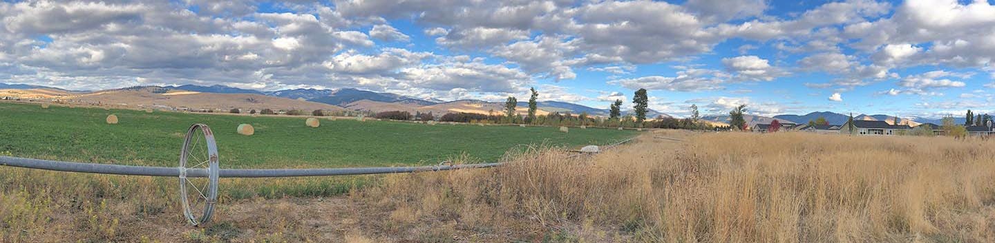
- Agricultural land throughout the Missoula Valley is a precious and vital resource that has slowly been paved over and replaced by housing and the infrastructure to support an ever-growing population. The area designated as the Mullan BUILD is situated on roughly 2,000 acres of prime if irrigated soils, just outside the city limits. Within the BUILD area sits one of the first homesteads. This area has been continuously used for agriculture throughout Missoula’s history. The BUILD plan will eliminate a large majority of this prime soil, and once that is gone, it cannot be replaced.
- This plan acknowledges the historical significance of this land, as well as the loss of potential agricultural production. Within the plan is a vision of incorporating a portion of agricultural land that will complement and enhance the neighborhoods within the BUILD area. Within this area are two significant areas specifically allocated for farms, along with a provision for community gardens spread throughout the different neighborhoods. In total, nearly 230 acres will be potential areas of agricultural production, and/or community garden space.
- Within the report findings, there is very clear and strong public support for agriculture, and we support the plan to incorporate farms and community agriculture within the plan. We recognize that without the master plan, there will be no conservation of these soils, as individual developments will simply pass the responsibility on to the next development, and we will continue to lose more and more of this critical foundation to our food security.
- While there has been much thought on the preservation of agricultural soils, inclusion of community gardens, and farm to table amenities throughout the area, there is still a significant loss of overall agricultural soils. CFAC recommends that this is mitigated in a significant way, such as is recommended within the report – with a mitigation fee for off-site conservation of ag soils in the future, and with conservation development within the BUILD area. We acknowledge that this is a necessary growth and that it is an appropriate placement of the needed housing. However, it is a very large loss of vital agriculture that must be mitigated. CFAC recommends that there is an explicit, written commitment to ensure protection in this planned development and with off-site mitigation within the Missoula Valley.
- Within the BUILD area, in the flight zone directly to the east of the current runways, CFAC recommends a permanent conservation easement that will serve as a buffer between the flight pattern and built homes. In utilizing a conservation development design, homes could be grouped at the far east end of this zone, while conserving the maximum amount of prime soils, yet providing the same, or more dwelling units within a smaller footprint.
- Overall, CFAC is in support of this plan, as it will condense housing into the area, leaving portions of the surrounding Grass Valley as an agricultural zone, with appropriate measures taken to preserve those areas in the future. CFAC requests a plan for the enforcement of the conservation and the stewardship of the lands conserved.
- CFAC is committed to the successful development of the farms within this BUILD area. We will work with the City, County, willing landowners and developers, and other non-profit organizations to ensure that the lands designated as agricultural areas are utilized as designed. CFAC has a long history of providing resources to farmers to ensure their success, and of connecting consumers to farms to build a local food and farm system. This BUILD area will provide a showcase of the potential to replicate these types of planned neighborhoods throughout Missoula, and to increase production of local foods in close proximity to markets, restaurants, and people’s homes. We look forward to seeing the success and growth of our food economy as a result.
Thank you for all the public engagement and amount of thoughtful time put into this master plan.
i agree w/Vicki Watson on preservation and protection of Grant Creek. i share Apryll's concerns for the bird and other wildlife currently observed in the area: “Hiawatha
Farm” in one part of the plan, is a riparian ecosystem that allows for an abundance of wildlife. i also agree w/Vicki Watson:
"preservation and protection of Grant Creek.Grant Creek is on MT DEQ’s list of impaired streams. Stakeholders working on a Watershed Restoration Plan for the Central Clark Fork prioritized improving Grant Creek. Hence development must be planned & executed to avoid worsening the situation, & should strive to improve the creek’s condition. This requires: 1 Detailed hydrologic study of Mullan area watershed to assess impact of proposed development on groundwater/surface water. This study informs where to place high density development (on less permeable soils) & where to place stormwater green infrastructure. 2 A creek buffer must be protected from development now – so creek can be restored when sufficient funds are found. Buffer width depends on purpose. To restore water quality, buffer 100 ft either side of creek or 100 year floodplain – whichever is greater. For good fish habitat, buffer 300 feet either side of creek or 100 year floodplain. A 300 foot buffer is also recommended for good songbird habitat with some species needing up to 660 feet. A buffer can also help absorb storm water runoff (width guided by the hydrologic study). To accommodate park trails, more buffer may be needed. Citations of scientific studies supporting these buffer widths available on request."
vicki watson about 19 hours ago. i also agree w/a member of the Five Valleys Audubon Society, I am now aware of this Mullan Area Master Plan. As the City and County develop more human spaces, there needs to be a plan for preserving and restoring wildlife habitat. It would appear that this "master plan" has the opportunity to enhance the riparian corridor of Grant creek. this would somewhat offset the loss of open space and important bird habitat. I recommend engaging the experts on habitat enhancement (e.g. Audubon, Clark Fork Coalition, University of Montana) to strike this important balance between human development and preservation of wildlife habitat.
kathy22 about 2 months ago kathi22
We would like to add to our last comment. We believe it is extremely important to provide for safe crossings of Reserve Street, for all people and especially those that are walking or cycling. Two ways we suggest to do this: one is for a bike/walk path to go under Reserve Street at the north side of the Clark Fork river. There is already the space to do this and it would be an easy way to make for a safe crossing. No bridge modifications are needed- the under crossing is basically already there. It would be similar to the trail going under Madison, Higgins, Orange and Russell, along the river. This new undercrossing at Reserve should then connect both east and west. To the east: the trail can go along the Clark Fork river and connect to the trail that was just completed under the new Russell bridge. There is space already for this mile long trail. One point of the right of way is 'tight' yet this trail is very feasible. We have walked the route many times over the last couple decades, to explore the feasibility. Connecting the trail to the west: this simply means working with Walmart for a good connection and also going thru the City owned waste water treatment area- a trail along the river would not interfere with either operation and could easily be constructed. This river trail heading west would connect with the Old Milwaukee trail already being planned by Parks and Rec and connect with the existing trail along Mullan road. A second crossing of Reserve can be done right at the Mullan intersection by going under Reserve Street at this location. The key is that there already is a natural grade change so this undercrossing would be much easier than it sounds. Ideally we would have both (and more) safe undercrossings of Reserve Street, to facilitate ease of walking and cycling. Thank you, -Bob Giordano, Director, MIST, mist@strans.org
Grant Creek is on MT DEQ’s list of impaired streams. Stakeholders working on a Watershed Restoration Plan for the Central Clark Fork prioritized improving Grant Creek. Hence development must be planned & executed to avoid worsening the situation, & should strive to improve the creek’s condition. This requires:
1 Detailed hydrologic study of Mullan area watershed to assess impact of proposed development on groundwater/surface water. This study informs where to place high density development (on less permeable soils) & where to place stormwater green infrastructure.
2 A creek buffer must be protected from development now – so creek can be restored when sufficient funds are found. Buffer width depends on purpose. To restore water quality, buffer 100 ft either side of creek or 100 year floodplain – whichever is greater. For good fish habitat, buffer 300 feet either side of creek or 100 year floodplain. A 300 foot buffer is also recommended for good songbird habitat with some species needing up to 660 feet. A buffer can also help absorb storm water runoff (width guided by the hydrologic study). To accommodate park trails, more buffer may be needed. Citations of scientific studies supporting these buffer widths available on request.
The Mullan Master Plan looks pretty good overall. It seems we are on a good track, yet more can and should be done, to create a healthy and sustainable Mullan area, and how it relates to Missoula as a whole. We focus our comments on transportation and land use, our expertise over the last 25 years in Missoula. While the plan shows good design for bike, walk and transit, we need to do more as to not create too many car trips. Missoula has a goal to triple bike, walk and transit, so the highest priority needs to be made for good design, incentives and new creative ways to keep people from driving so much. We support the internal street and trail designs and we also support more attention to detail once things get built. For instance, it can be challenging for pedetrains if cyclists are also sharing those facilities in a street context vs. a trail context. We greatly support much more transit interfacing with the Mullan plan and development. We support even more bike walk trails connecting within and thru the development area. We also greatly support modern, single lane roundabouts and do not think we should be building any multi lane roundabouts, or even roundabouts with auxillary lanes. The roundabout at Mullan/ George Ellmer shows auxillary lanes: this makes it less safe and comfortable for people walking and cycling. So please work towards 'pure' single lane roundabouts for all intersections, including those with Broadway. We highly suggest '3-laning' Broadway, which is wider than an airport runway right now. A 3-lane street with modern single lane roundabouts typically moves traffic much safer and even more efficient than a 4 or 5 lane street with signals. Broadway, and Mullan for that matter, can be beautiul 3-lane streets, with single lane roundabouts, and separate cycle tracks and boulevard sidewalks. A separate bike walk trail can even/should be off to the side of these potential 'complete streets.' Frequent, good-coverage transit is also essential and will help with our collective mode shift goals. Instead of any multi lane or auxillary lane roundabouts connecting the development to greater Missoula, please do 3-lane streets with only _single_ lane roundabouts, yet perhaps secure right of way to 'upsize' the roundabouts if absolutely necessary in the future. Our strong hunch is that transportation is changing quickly and on a large scale, and so it is prudent to keep things as small as possible right now. This saves money, energy and lives. We follow international roundabout design trends and it is clear that single lane rounabouts are good for walking and cycling while multi lane roundabouts generally are not. We are also excited to see the momentum behind passenger rail restoration in the Missoula Valley, so this transportation mode cannot be discounted. In fact, it should be planned for. Other mobility enhancements for the Mullan area should include: bike share, car share, sustainable paving (permeable for instance) techniques, slower speeds (thru good design, such as 10' lanes), high-quality, secure bike parking (covered), bike fix-it stations and neighborhood greenways. If these techniques are employed up front, then development and people's habits conform and adjust- seemlessly- right away. It is much harder to retrofit and change habits later. We also want to 'plug' as much mixed use development as possible. In a way, we are creating a new community, even a new city, in the Mullan area. All services should be within, such as getting food, building supplies, jobs, night life, recreation and all other life requirements. Thank you, -Bob Giordano, Director, Missoula Institute for Sustainable Transportation, mist@strans.org
The overall Mullan Master Plan raises multiple concerns, but there is also rezoning that was being proposed that will significantly increase those concerns. The proposed 347 residential lots would be a density increase that would overwhelm the current and proposed infrastructure changes, making it extremely difficult to navigate the division streets as well as Mullan Road. I am concerned with the number of people that would inhabit an area with currently 1 road going East into town, and only a second proposed road with the connection to Broadway. There are already times during the day where it is almost impossible to turn East onto Mullan, especially during the winter months. This rezoning proposal of multi-family style units would congest the area even further, making it more difficult than it already is.
My other concern with the type of housing that is being proposed is the increase in potential rental units, and transitional housing that would create inconsistencies with the current dwellings being built in the division, and the future construction of the proposed units. Currently we have single-family units in our division, some of which are rentals, but still adhere to the architectural aspects of single-family homes. Adding courtyard/patio style dwellings, row houses and townhome/duplex style dwellings would decrease the desire to live in a development specifically designed with single-family homes, thus decreasing the property values of those who already reside in this subdivision.
My final concern is that this is a very child-friendly subdivision, with hundreds of kids who are frequently out and about with their friends. Adding the proposed 347 residential units greatly increases the population density, which in turn increases the traffic within the subdivision streets. That will increase the danger of those children being injured as a result of the increased frequency of cars on the road.
The proposed rezoning will bottleneck the already congested streets coming out of the 44 Ranch Development, as many people work in town around the same time. This bottlenecking not only has an impact on those who live in the division, but for those who live further west on Mullan, who have only one route to drive into town. Assuming one car per dwelling (and maybe more for transitional housing, as many people have roommates), the increase in population density will overwhelm the current and proposed infrastructure. There will be a greater danger to the children who have a wonderful area and neighborhood to play in, and will decrease the property value of the homes that are already build, and will continue to be built within the development.
The Mullan Master Plan looks great. One important clarification is needed.
REFERENCES MUST BE MADE AS WELL AS EMPHASIZED TO INFORM RESIDENTS* that MPO (Missoula Metropolitan Planning Organization – in charge of planning and providing a safe and efficient transportation system), intends to improve Mullan Road.
• Residents need to know that the Mullan Master Plan Development Team and MPO have congruent plans, including the need to make Mullan Road safe, convenient, and able to accommodate the ongoing and significant increase in vehicle traffic.
• Without a clear understanding, concerned residents are left to imagine the worst regarding normal, daily traffic as well as dangerously obstructed traffic, of personal and emergency vehicles, in the event of evacuation.** Montana’s wildfire history, the current fires on the west coast, and the reality of climate change make evacuation a distinct possibility.
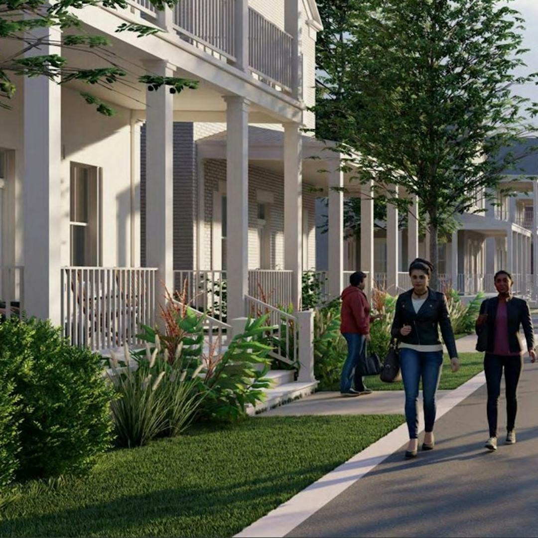
The Mullan Master Plan introduces the goal of expanding Missoula’s housing options along with the creation of an attractive, safe, and livable neighborhood community.
*City and County proposals often use condensed, vague language. Continue to clarify by using easily understood words and sentences.
**Mullan Area offers the appeal of wildland/urban interface as well as classification as a high wildfire risk area. Residents depend on city and county government to continue its obligation to safe guard the public.
September 21, 2020
Missoula Consolidated Planning Board
127 East Main Street, Suite 2
Missoula, MT 59802
To Whom It May Concern:
We are residents of the Pleasant View neighborhood. We wish to express our concerns about the Adoption of the Mullan Traditional Neighborhood Development Form-Based Code. We realize that you are in the beginning stages of this approval process, but would like to express our concerns about the traffic burdens that will obviously affect our neighborhood. Based on the boundaries of this proposed district, it appears that little consideration has been made on addressing adequate and safe traffic flow. Specifically, we are concerned that there appears to be limited streets being added to address north/south traffic flow, other than dumping most of the traffic on to England Blvd. Our homes border England Blvd. and we have noticed that traffic flow has increased significantly over the past few years. During the school year, there are no less than 10 school buses that use England Blvd causing increased noise and congestion twice daily. Our neighborhood association has been discussing options to address these concerns for years, but little has been done to resolve the traffic issues. We are hoping that you plan to study and address these traffic issues. There are several areas where traffic bottlenecks occur including both the north and south ends of Flynn Lane and the intersection of England Blvd and Reserve. For years we have been told that Mary Jane will eventually be expanded from Broadway to Mullan Rd to relieve this congestion, but to date no changes have been made to facilitate this. Some of the suggestions that have been made to address these bottlenecks include adding a stoplight at both ends of Flynn Lane and adding a right hand turn lane at the intersection of England and Reserve; but again, we have seen no progress regarding these suggestions. We would be interested in knowing what you plan to do to adequately address the current and future traffic flow issues. Will there be a process for those of us living in this area to be able to provide input to your planning board? Your letter dated September 11, 2020 mentioned that notification went out to all property owners within the proposed rezoning or within 300 feet. We feel that you should expand this notification to all residents of Pleasant View Estates, as the increased traffic flow will affect this entire neighborhood. We look forward to hearing back from you regarding our concerns.
Respectively submitted,
Leslie and Phillip Mullette
2798 Fleet Street
Thank you for this opportunity to submit comments regarding the Mullan Road Redevelopment. After many years of concern for the area behind my home, I am grateful to have this platform with which to communicate.
I am commenting today on the issue of conservation. The area at the west side of the proposed plan, labeled “Hiawatha Farm” in one part of the plan, is a riparian ecosystem that allows for an abundance of wildlife. This area was part of a flood plain mitigation that includes the subdivision I live in. This mitigation was within the last 2 decades, and subsequently has created an area that now has water throughout the year. As a result, habitat exists now where a diversity of wildlife are present. There is a family of Red-Tailed Hawks and a family of Great Horned Owls that live in the trees just above the water. Blue Herons fly overhead and use the cottonwoods as nesting sites. There are visiting Sandhill Cranes each summer. Additionally, there are deer, coyotes, skunks, foxes, frogs, toads, ducks, geese, Red-Winged Blackbirds, Yellow-Headed Blackbirds, and many other birds that choose to visit, live, and nest in the area. There has recently been a family of Bald Eagles with two juveniles frequenting the area as well. Is there any type study being done to determine the effects on wildlife as we spread our urban developments? If not, I would humbly request that this be part of the process for this area. And in determining those potential effects, what will you do to mitigate them?
After reading much of the proposed plan at mullanareamasterplan.com, I feel like Dover, Kohl, & Partners offers a unique approach to the area. It is inspiring to see an alternative to housing development that is not based solely on how many units they can put in one acre or how much money they will be able to get out of the project in the long term. However, the current plan, as written, seems to focus on conservation for human use and recreation rather than conservation for the wildlife systems that exist in these areas.
It is my opinion that the City of Missoula has approved far too many multi-family dwelling units that destroy habitat, block mountain views, create traffic congestion, and do not fulfill the true desires of the people who have lived here for decades. Many of the apartment areas that have been built toward the west end of Missoula are not anything like what is being proposed in the Mullan Area Master Plan. They lack the CSAs and farm areas, community centers, trails and parks. I am concerned that the vagueness of the zoning request would allow developers and the city to take advantage and create further population density in the area. How can you assure surrounding landowners that our wildlife areas, views, and peace will not be impeded?
As my main concern is the for the property directly north of the Mullan Trail subdivision, I would like to request that specific measures be required for building sites. As it is stated currently in the plan, the possibility of apartments and multi-family housing exists. This would mean increased population density in the area which brings noise, light, and consumer pollution. It does not reflect abundant wildlife conservation efforts in that area, and I am deeply concerned about this. In the Master Plan documents, I find it confusing and vague that there are multiple maps that indicate “Community Center” or “Hiawatha Farm”. These terms do not have any solidification at this point and seem arbitrary and vague. Please consider the landowners to the south of the proposed plan in the final proposal. I would like to suggest a height restriction on buildings, the elimination of the multi-family units in that area, and fewer through-traffic areas. Many of the residents in the area use Hiawatha Road as a walking trail for our families and pets, and we would appreciate your consideration of our lifestyles in your decision making.
In closing, I understand that Missoula is growing and there are many people who want to call our beautiful valley home, regardless of how I feel about it. However, wildlife conservation is fundamental to Western Montana, and Missoula’s growth should reflect our values. I ask that you consider an option for the area I have addressed that is reasonable, applicable, and sound based in conservation standards and goals.
Thank you.
Planning this community for less energy intensive travel methods (i.e. biking, walking, and bussing) aligns with the need for Missoula (and all communities) to start moving towards a less energy intensive way of living to mitigate climate change impacts. Connecting this bike friendly neighborhood to downtown would be an important consideration as well to ensure there are alternative transportation options to driving. To adapt to the climate changes we're already seeing, this plan could incorporate native plants in landscaping designs to support pollinators, reduce the need for watering, and minimize mowing.
One large concern I have is how the additional housing added though this plan will be kept affordable for Montana workers. Could there be options such as rent controls to keep housing options affordable? The 'cottages' described are an excellent vision for transitioning toward a less consumptive lifestyle that hopefully would allow more, smaller, affordable homes.
Another means of creating affordable homes may be to partner with Habitat for Humanity for some of the new homes, especially given their new approaches to reducing the costs of homes long-term, for subsequent owners.
A vision for renewable energy was described in one of the meetings, and I would propose a community shared solar option. By developing a larger solar array (or several larger arrays) throughout the community, renters and homeowners in the new development could lease, own, or subscribe to a portion of the energy generated right in their neighborhood. This local generation could help offset the energy consumption of the new development, aligning with the city and county goals of 100% renewable energy.
While I was born in Missoula in '47, we didn't move here until '52. I was fortunate to live here in those early days, and to get to enjoy the slant streets for 40 years. I moved to Flynn Ranch last summer. I could no longer take care of my former home, and found a stand alone home with no steps and an HOA who handles mowing and shoveling, important at my age. I am less than a mile from my son. But my peaceful neighborhood is about to change for the worse. George Elmer will go from the dead-end by my house to a major street. The farm land across from me will become a neighborhood with multiple use housing and buildings more than two stories. That field is and its adjacent trees are currently home to red tailed hawks, geese, and so many other birds, and even fox and coyotes. Why can't we keep some farm land and open space? Why do we have to cater to so much new growth? I am aware that my neighborhood is on former Flynn Ranch farm land. But we are a community with covenants and neighborhood pride, not a hodge podge of buildings. I do not like my native city any more!!
The survey responses demonstrate what generally happens with public outreach in Missoula. The people who commute by alternative means (biking, walking, transit) turn out while those of us who drive our cars (a huge percentage of the overall population, especially in the Mullan area) are busy trying to commute through vast amounts of Missoula traffic and possibly traveling to Ravalli County to escape the high Missoula housing costs. The idea that this build-out should include a lot of biking and walking is unreasonable. Make the roads so they can handle the terrible traffic congestion. Mullan Road needs to be 4 lanes for a start, and that's before you add further impacts. Once more traffic is entering from Flynn, George Elmer or the proposed Mary Jane extension, Mullan won't be passable from those points to Reserve Street. The idea that we would cram more houses, and therefore more cars, into an already overcrowded system is insane. I agree with the comments from NateP regarding housing types. Stacking condos and townhomes on top of each other doesn't solve the terrible road infrastructure problem. As a person who was born and raised in Missoula, and has lived out Mullan Road for 16 years, I have seen the city deteriorate precipitously over the last 3-4 years with infill housing to try to accommodate a population that just can't "fit" into Missoula. We're slowly killing the special vibe/environment that has always made Missoula special, making it like any other crowded, polluted urban center.
I would like to see a free campground funded by the city and county located on land near the prison. Within walking distance of the pov and bus station. Will also provide legal authority to prevent encampments at reserve, broadway island and elsewhere.
I respectfully disagree with the planning. I am sick of seeing our town built up with condo after condo, townhome after townhome, making the city 20% more condensed, populated, and crowded than it should be. If anything, there should be actual houses and neighborhoods where people have the space they need to actually live. Utilizing all these condos and such, stacking the population on top of each other you are making the streets even more congested and the city is at its limits of what it can handle as far as transportation logistics.
Please stop building condos and townhomes, and please fix the traffic congestion. Look into a bypass like Kalispell has done.
First off, the commitment to public input and stakeholder engagement is evident throughout. I was not at the public engagement , but feel like I was after reading the document. My general impressions follow. The value of preserving, protecting, and enhancing the Grant Creek corridor is apparent in the document and is appreciated. I respect the integration of hyper local food and agriculture with new neighborhood development. There is a consistent focus and priority placed on providing shared use trails for bikers and walkers, complete streets, and street trees throughout all of the neighborhoods design. This proclaims “We want people to be able to safely choose biking and walking, and we want slow, safe car traffic!” I love the attention to the “missing middle” of housing choices with bungalow courtyards, townhomes, and the like. Your plan stresses that sustainable building and planning is nonnegotiable. I appreciate the commitment to electric car charging spaces, solar, and green building standards. Your design’s greatest strength is that it is anchored in many different ways. There are intentional neighborhood centers for gathering, the past is honored through historic preservation, farmland and agriculture are respected and preserved, and your design allows for a myriad of community members to live, work, and learn together. I did not see any reference or requirement for diversity of architecture/color/materials for development and this is especially evident in the Hiawatha neighborhood renderings. Another feature of some new developments I appreciate is underground parking for the higher density areas. It is not specifically discussed, but visually and practically makes the streets less crowded. To me, the priority is to build the complete streets, all the shared use trails, set aside the park land/neighborhood squares, set aside land for the school and fire station, protect/acquire the historical sites, and acquire the conservation easements you need for the farms/CSA. This plan discusses the need to safely cross Reserve on a bike/walking but does not touch on it. That also seems very important with such density. Because this appears unresolved, the neighborhood proposed by West Broadway and the new VA would be my first choice for the neighborhoods to be developed.
Regarding the Mullan Master Plan. I strongly encourage that the master plan take into account protections and enhancements for the Grant Creek corridor. Specifically, protecting this riparian zone that is crucial for a wide variety of bird and animal species. As time goes on, more and more wildlife habitat will be lost to development at the long term expense of nature. Preserving these areas along with inevitable development is the right choice now, as once it is lost it will never be recovered. The people of Missoula greatly value our wild creatures and natural environment. Please protect this vital area for wildlife and all future generations of our magnificent valley.
I am writing to comment on the Mullan Area Master Plan, especially in consideration of the habitat that should be maintained and enhanced through the planning process for the development of the area. Of particular concern is the importance of preserving and enhancing the riparian habitats along Grant Creek. The little stretches along Grant Creek are riparian zones, with habitats that are home to a wide range of flora and fauna that meet birds’ survival needs. Successful bird migration and nesting depends on this habitat that provides food, water, shelter, song posts, perching locations and nest sites. Riparian zones provide all of these features and support some of the most abundant and diverse bird communities in the West. On one day in mid-May, we counted 24 species of song birds along Grant Creek, many being Neo-tropical migrants.
From the experts at Five Valleys Audubon Socieity: “The Mullan Plan should call for an open-space and riparian buffer area along the entire length of Grant Creek. It should exist on both sides of the creek channel and, as a minimum, extend 150 feet from either side of the channel. Toward facilitating consistent management, this space should exist in the form of a no-build common area. A protected open space of this size would set the stage for a return of native riparian vegetation and reduce the impact of human activity on wildlife using the area. Serious consideration should also be given to a focused stream rehabilitation effort as a means to increase the pace of the habitat recovery process. Accomplishing such an undertaking would require an expressed commitment in the plan to acquire the necessary funding.”
Restoring and protecting riparian habitat along Grant Creek is crucial to protecting our natural heritage. Thank you for considering this in the Mullan Area planning.